Download Terrasolid Suite 2025 – Advanced LIDAR and Image Processing Software
Terrasolid Suite 2025, developed by Terrasolid Ltd., is a specialized software suite designed for advanced LIDAR data processing and image analysis. Tailored for civil engineering, mapping, and remote sensing professionals, this suite enhances the capabilities of users working with complex geospatial data. It serves as a critical tool for those requiring precise data extraction and manipulation, particularly within the context of large-scale engineering and mapping projects.
Overview of Terrasolid Suite
What is Terrasolid?
Terrasolid Suite is a comprehensive collection of applications engineered to process and analyze data acquired from laser scanning and LIDAR technologies. Primarily noted for its seamless integration with Bentley systems, the suite empowers geospatial professionals and civil engineers to achieve higher accuracy in their mapping and surveying endeavors. Its modular design allows for specialized processing of various data types, ensuring efficient handling of extensive datasets common in modern infrastructure and environmental projects.
Key Components of Terrasolid Suite
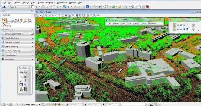
TerraScan for LiDAR Data Processing
TerraScan is the cornerstone application within the Terrasolid Suite, focusing on the detailed processing of raw LIDAR data. It offers robust tools for filtering noise, classifying points into logical categories (such as ground, buildings, and vegetation), and extracting specific features from point clouds. Its advanced algorithms enable users to handle large volumes of data efficiently, producing highly accurate terrain models and feature data essential for detailed geographic analysis and mapping.
TerraSlave for Enhanced Performance
To manage the computational demands of extensive LIDAR datasets, Terrasolid Suite includes TerraSlave. This component is designed to distribute processing tasks across multiple computers, effectively optimizing the use of available computing resources. By enabling parallel processing, TerraSlave significantly reduces the time required for complex operations, allowing professionals to accelerate their workflows without compromising on the quality or detail of the data analysis.
TerraPhoto for Image Processing
TerraPhoto is a specialized module within the suite dedicated to the processing of aerial and terrestrial imagery. Its primary function is to create accurate and seamless orthophoto maps and digital mosaics from overlapping images. This capability is crucial for generating visually rich and geographically precise representations of project sites, which can then be integrated with LIDAR data for comprehensive project planning and assessment.
TerraMatch for Image Accuracy
Ensuring the geometric integrity and accuracy of processed imagery is the role of TerraMatch. This application is key to refining the alignment and orientation of overlapping images, correcting for distortions and ensuring a unified, accurate representation. By meticulously managing image overlaps and adjusting positional data, TerraMatch significantly enhances the overall quality and reliability of the final mosaiced products derived from aerial or drone-based imaging systems.
Application in Civil Engineering and Surveying
The Terrasolid Suite plays a pivotal role in advancing the accuracy and efficiency of civil engineering and surveying projects. By providing specialized tools for LIDAR data processing and image analysis, it enables professionals to create highly detailed and precise digital terrain models, conduct thorough site analyses, and monitor construction progress with unparalleled accuracy. The suite’s compatibility with Bentley systems ensures that these advanced capabilities can be easily integrated into existing engineering workflows, streamlining project execution from initial survey to final design.
Use Cases and Industry Applications
The Terrasolid Suite finds extensive application across various high-precision sectors. Professionals leverage its advanced capabilities in several key areas:
- Infrastructure Development: Used for detailed topographic surveys, corridor mapping for roads and railways, and site planning for new construction projects.
- Environmental Analysis: Supports the creation of precise elevation models for flood risk assessment, watershed management, and ecological monitoring.
- Urban Planning: Facilitates the generation of detailed city models for spatial analysis, infrastructure management, and smart city initiatives.
- Geological and Mining Surveys: Aids in the precise mapping of terrain, resource identification, and monitoring of earth movement or excavation volumes.
- Forestry and Agriculture: Enables detailed canopy analysis for forest management and precision agriculture applications through LIDAR data interpretation.
Conclusion
Terrasolid Suite 2025 offers a powerful and specialized solution for professionals engaged in advanced LIDAR data processing and geospatial analysis. Its suite of integrated applications, including TerraScan, TerraSlave, TerraPhoto, and TerraMatch, provides the tools necessary for high-accuracy mapping and surveying. For civil engineers, surveyors, and mapping specialists requiring robust data handling and precise output, the Terrasolid Suite, particularly in conjunction with Bentley software, stands as a valuable asset for critical project success.
Frequently Asked Questions
What types of projects can benefit from Terrasolid Suite 2025?
Terrasolid Suite 2025 is ideal for civil engineering and surveying projects that require precise LIDAR data processing and image analysis. This includes complex tasks such as infrastructure development, detailed environmental studies, urban planning initiatives, and any application demanding high-fidelity geospatial data.
How does TerraScan improve LIDAR data processing?
TerraScan enhances LIDAR data processing by providing sophisticated tools for data classification, selective filtering, and in-depth feature analysis. This allows users to efficiently extract valuable insights, such as detailed terrain representations and specific object identification, from raw point cloud data.
Can I use Terrasolid Suite with other engineering software?
Yes, Terrasolid Suite is specifically designed to integrate seamlessly with Bentley products. This integration enhances the core functionalities of Bentley software by adding specialized capabilities tailored for the unique demands of LIDAR data processing and advanced mapping applications.


Reviews
There are no reviews yet.