
Download DELPH INS Subsea 3.0.7 – Advanced Subsea Navigation Software
DELPH INS Subsea 3.0.7, developed by iXblue, is a specialized subsea navigation software designed for processing and monitoring data from inertial navigation systems (INS). This application is crucial for professionals in the Oil, Gas, and Energy sectors involved in complex subsea operations, offering advanced post-processing capabilities and seamless integration with various subsea navigation tools and sensors.
Overview of DELPH INS Subsea
Company Background: iXblue
iXblue is a prominent company dedicated to developing cutting-edge maritime technologies. Their focus on innovation drives advancements in positioning, navigation, and underwater acoustic systems. The development of DELPH INS Subsea underscores iXblue’s commitment to providing robust solutions for demanding underwater environments, supporting critical operations in industries like offshore energy and marine construction.
Key Features of DELPH INS Subsea 3.0.7
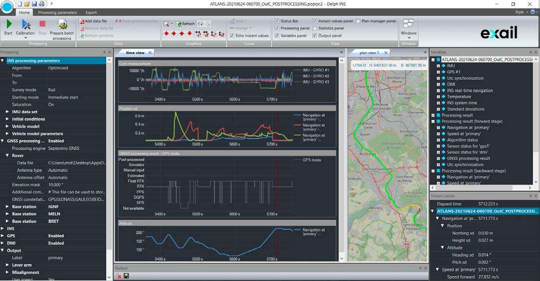
Post-Processing Capabilities
DELPH INS Subsea 3.0.7 enhances data analysis through its sophisticated post-processing features. These tools allow engineers to refine raw navigation data for increased accuracy and reliability. The software supports various data visualization options and quality control checks, crucial for post-mission analysis.
Real-Time Monitoring
The software facilitates real-time data integration, enabling operators to monitor navigation system performance as operations are underway. This immediate feedback loop is essential for making timely adjustments and ensuring mission success in dynamic subsea environments. Real-time display of key navigation parameters aids in immediate decision-making.
Applications in the Oil and Gas Industry
In the oil and gas sector, DELPH INS Subsea plays a vital role in numerous subsea operations. It is specifically tailored for use with Remotely Operated Vehicles (ROVs), Autonomous Underwater Vehicles (AUVs), and towfish. These vehicles require precise navigation for tasks such as pipeline inspection, subsea structure installation, and resource exploration, where accurate positioning is paramount.
Integration with Third-Party Sensors
To achieve comprehensive navigational accuracy, DELPH INS Subsea supports the integration of data from various third-party sensors. This includes GPS for surface positioning, Ultra-Short Baseline (USBL) and Long Baseline (LBL) acoustic positioning systems, and Doppler Velocity Logs (DVLs). By fusing data from these complementary sources, the software significantly enhances the precision and robustness of subsea navigation solutions.
Usability Enhancements and User Experience
DELPH INS Subsea 3.0.7 incorporates several usability enhancements designed to improve the user experience. The interface has been refined for more intuitive navigation and operation, reducing the learning curve for new users. These improvements facilitate smoother integration into existing workflows and allow for quicker adjustments and data management, even for complex projects.
Impact on Subsea Navigation Workflows
The capabilities of DELPH INS Subsea have a significant positive impact on subsea navigation workflows. By offering advanced post-processing tools and streamlining the integration of diverse data streams, the software helps engineering teams reduce processing times and improve the overall efficiency of their operations. This leads to more reliable data sets for analysis and decision-making. The advanced DVL post-processing software capabilities are particularly beneficial for enhancing accuracy.
Conclusion
Utilizing DELPH INS Subsea 3.0.7 is essential for modern subsea navigation systems in the oil and gas industry. Its advanced features for data processing, real-time monitoring, and sensor integration, combined with an enhanced user experience, provide critical support for complex underwater operations, ensuring precision and reliability in navigation.
Frequently Asked Questions
What is DELPH INS Subsea used for?
DELPH INS Subsea is designed for the post-processing of data from inertial navigation systems (INS) utilized in subsea applications. It also provides features for real-time monitoring and integrates data from various third-party sensors to enhance navigational accuracy and aid in comprehensive data analysis.
What types of sensors can be integrated with DELPH INS Subsea?
The software supports the integration of a wide array of sensors crucial for subsea navigation. This includes GPS for surface positioning, USBL and LBL acoustic positioning systems, and DVLs, enabling the fusion of diverse data sources for improved navigational accuracy.
How does DELPH INS Subsea improve data processing efficiency?
It offers advanced post-processing features specifically tailored for subsea data, supports customizable map projections, and provides an intuitive user interface. These elements collectively promote smoother data integration, quicker workflow adjustments, and more efficient overall project management for subsea navigation tasks.


Reviews
There are no reviews yet.