
Download TopoFlight MISSIONPLANNER 2024.0.2 – Advanced Flight Planning Tool for Photogrammetry and LiDAR
TopoFlight MISSIONPLANNER 2024.0.2 is an advanced flight planning software developed by TopoFlight, Inc., specifically engineered for professionals in the photogrammetry, LiDAR, aerial surveying, and GIS industries. This tool is designed to optimize aerial mission planning by leveraging digital elevation models, significantly enhancing efficiency and reducing operational costs for complex surveying projects.
Introduction to TopoFlight MISSIONPLANNER
Overview and Significance
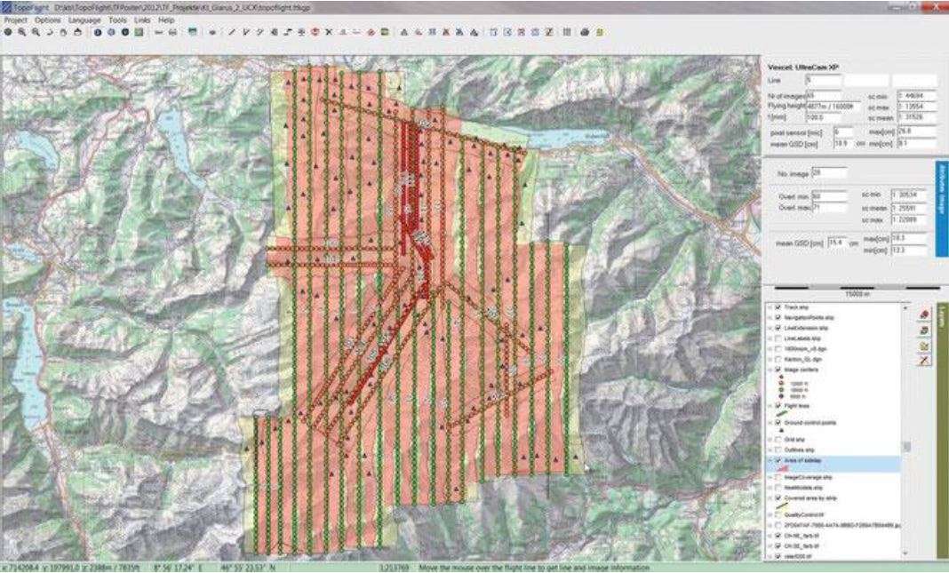
TopoFlight MISSIONPLANNER serves as a critical component for modern aerial data acquisition workflows. Its primary function is to facilitate the creation of highly efficient flight paths tailored for photogrammetry and LiDAR surveys. By integrating advanced planning features with digital elevation models (DEMs), the software ensures that missions are planned with precision, minimizing redundant data collection and maximizing the value of captured aerial imagery and sensor data.
Key Features and Capabilities
Flight Planning and Optimization
This software provides sophisticated tools to create optimized flight plans for various survey requirements. Users can define mission parameters, including area coverage, desired overlap, and sensor specifications, allowing the system to generate precise flight lines and waypoints.
- Automated flight path generation based on project boundaries and survey objectives.
- Customizable flight parameters such as altitude, speed, and sensor angles.
- Tools for defining no-fly zones and specific survey areas.
Integration with Digital Elevation Models
A core capability of TopoFlight MISSIONPLANNER is its robust integration with digital elevation models. By utilizing DEM data, the software can accurately predict terrain variations and adjust flight altitudes accordingly, ensuring consistent sensor altitudes above ground level. This feature is fundamental for achieving high-quality data acquisition in diverse and challenging terrains.
- Generation of 3D flight paths that conform to terrain elevation.
- Improved image acquisition by maintaining optimal sensor distance to the ground.
- Reduction in the number of flight lines and images required for complete coverage.
Export Interfaces and Compatibility
TopoFlight MISSIONPLANNER supports a range of export formats, enabling seamless data transfer and integration with other flight management systems and data processing software. This compatibility ensures that the planned missions can be directly uploaded to flight control systems and that the mission data aligns with subsequent photogrammetric or LiDAR processing workflows.
- Export of flight plans in standard formats compatible with various UAV autopilots and manned aircraft systems.
- Data export options that provide mission logs and waypoints for post-flight analysis.
- Compatibility with leading GIS and photogrammetry software packages for streamlined project management.
Applications in Photogrammetry and LiDAR Missions
The applications of TopoFlight MISSIONPLANNER are diverse, primarily focusing on professional aerial surveying tasks. Its specialized features make it an indispensable tool for projects that demand high accuracy and efficiency in data capture. Professionals utilize it across various scales, from small regional surveys to large-scale infrastructure mapping.
- High-resolution aerial mapping for urban planning and infrastructure development.
- Topographic surveys for construction, mining, and forestry management.
- Environmental monitoring and change detection studies requiring repeat aerial surveys.
- Inspection of critical infrastructure like bridges, power lines, and pipelines.
Real-World Use Cases
TopoFlight MISSIONPLANNER has been instrumental in numerous projects, demonstrating its versatility and effectiveness in real-world scenarios. Its ability to handle complex planning requirements makes it suitable for a wide range of operational scales.
- A large-scale national mapping project utilized TopoFlight MISSIONPLANNER to plan hundreds of flight hours, resulting in significant time and cost savings by optimizing flight paths over varied terrain.
- Smaller surveying firms employ the software for individual client projects, benefiting from its user-friendly interface and efficient planning capabilities to deliver detailed aerial data for land development and agricultural assessments.
- Infrastructure companies use TopoFlight MISSIONPLANNER for routine corridor mapping, ensuring consistent data capture for asset management and maintenance planning.
Comparison with Other Flight Planning Tools
Compared to general-purpose flight planning software, TopoFlight MISSIONPLANNER distinguishes itself through its specialized focus on photogrammetry and LiDAR applications. While other tools may offer broader flight planning capabilities, TopoFlight MISSIONPLANNER excels in its deep integration with digital elevation models and its precise optimization for survey-grade data acquisition.
- Its terrain-following algorithms are specifically tuned for survey accuracy, unlike generic path generators.
- The software’s export options are tailored to the data requirements of photogrammetry and LiDAR processing pipelines.
- A key differentiator is its emphasis on minimizing image overlap while ensuring complete ground coverage, directly impacting project efficiency and data volume.
Conclusion and Getting Started
TopoFlight MISSIONPLANNER 2024.0.2 represents a significant advancement in flight planning software for aerial surveying professionals. Its ability to optimize missions using digital elevation models, coupled with comprehensive export capabilities, streamlines workflows and enhances the accuracy of photogrammetry and LiDAR projects. By reducing flight time and data processing requirements, it offers a substantial return on investment for demanding geospatial applications.
To begin leveraging the advanced capabilities of TopoFlight MISSIONPLANNER, users can explore its features for their upcoming aerial survey missions. The software is designed to integrate smoothly into existing professional workflows, providing immediate benefits in planning efficiency and data quality.
Frequently Asked Questions
What is TopoFlight MISSIONPLANNER used for?
TopoFlight MISSIONPLANNER is primarily used for planning aerial missions in photogrammetry and LiDAR applications. It enables the efficient design of flight plans that integrate digital elevation models to optimize flight paths and reduce costs.
How does TopoFlight MISSIONPLANNER improve flight mission efficiency?
By incorporating digital elevation models, TopoFlight MISSIONPLANNER minimizes the number of flight lines and images required during missions, leading to more streamlined and cost-effective project execution and reduced data processing workload.
Can TopoFlight MISSIONPLANNER export to other flight management systems?
Yes, TopoFlight MISSIONPLANNER features various export interfaces that allow seamless data transfer to a wide range of flight management systems, facilitating smooth workflow integration into existing aerial survey operations.


Reviews
There are no reviews yet.