
Download 3D Space ProfLT 17.2 – Advanced Civil Engineering CAD Extension
3D Space ProfLT 17.2 is an advanced CAD extension developed by 3D Space, designed to enhance the capabilities of platforms like AutoCAD and IntelliCAD for civil engineering professionals. This software serves as a specialized tool for complex 2D and 3D land feature design, precise volume calculations, and the generation of high-quality maps, supporting critical workflows in civil engineering, land surveying, and geological applications.
Innovative Land Feature Design for Civil Engineering Projects
3D Space ProfLT integrates seamlessly with industry-standard CAD software such as AutoCAD and IntelliCAD. It significantly enhances their native functionalities by introducing a suite of specialized tools crucial for civil engineering design. Professionals can leverage this extension for detailed terrain modeling, comprehensive geological mapping, and intricate civil design workflows, enabling more accurate project planning and execution.
Comprehensive 2D and 3D Design Tools for Accurate Terrain Modeling
This software offers robust tools for creating and manipulating both two-dimensional and three-dimensional representations of land features. Its capabilities in generating detailed terrain surfaces are vital for accurate earthworks planning and infrastructure development. By providing precise control over land geometry, 3D Space ProfLT empowers engineers to design with confidence, ensuring that their models reflect real-world conditions effectively for projects ranging from road construction to site grading.
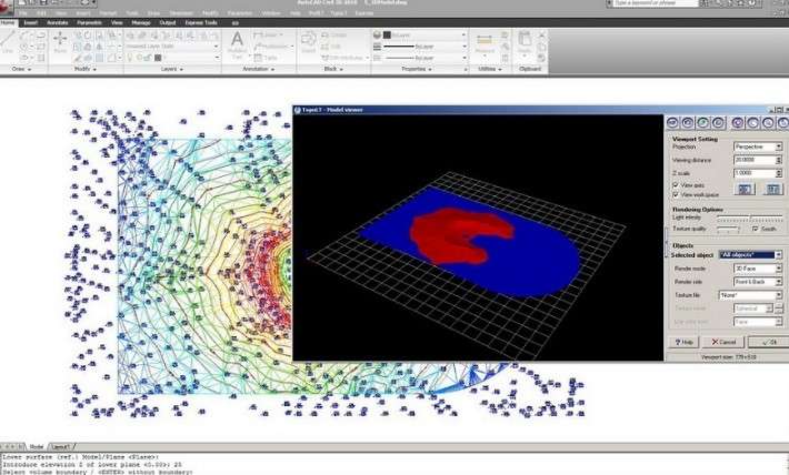
Precision Volume Calculation for Earthworks and Material Management
A key feature of 3D Space ProfLT is its advanced volume calculation functionality. This capability is indispensable for civil engineering projects as it allows for the precise estimation of earthwork quantities, such as cut and fill volumes. Accurate volume calculations are critical for effective project planning, optimizing material management, and establishing reliable cost estimations, directly contributing to the financial success and efficiency of construction endeavors.
High-Quality Map Generation and Printing Capabilities
3D Space ProfLT excels in producing high-quality maps that meet stringent professional printing standards. The generated outputs are detailed and visually accurate, making them suitable for official project documentation, client presentations, and regulatory submissions. This focus on map quality ensures that engineers and surveyors can deliver clear, professional deliverables that effectively communicate complex design information.
Customizable Settings to Streamline Repeated Project Requirements
The software incorporates versatile customization features that allow users to tailor settings to specific project requirements. These configurations can be saved and reused, significantly streamlining workflows for repetitive tasks across multiple projects. This adaptability minimizes rework and speeds up the initial setup phase, enhancing overall user productivity and ensuring consistency in design and output.
Integration and Compatibility with Major CAD Platforms
Designed as an extension, 3D Space ProfLT ensures high compatibility with widely used CAD platforms, most notably AutoCAD and IntelliCAD. This seamless integration allows users to leverage its specialized civil engineering tools without having to learn entirely new software environments. By enhancing existing CAD tools, it offers a powerful and efficient solution for complex land design and mapping challenges for surveyors and civil engineers.
Frequently Asked Questions
How does 3D Space ProfLT enhance AutoCAD for civil engineering tasks?
3D Space ProfLT acts as an add-on that extends AutoCAD’s capabilities by providing specialized civil engineering tools for 2D and 3D land feature design, volume calculations, and high-quality map outputs. This integration allows engineers to perform complex terrain modeling directly within their familiar CAD environment.
What types of projects benefit most from using 3D Space ProfLT?
The software is ideal for projects involving land surveying, earthworks, infrastructure development, and geological mapping where precise 3D design and volume calculation are essential for project success and cost control.
Can users customize the tool settings for different projects in 3D Space ProfLT?
Yes, 3D Space ProfLT allows users to adjust and save configurations tailored for different projects, enabling faster setup and minimizing repetitive tasks across multiple workflows.


Reviews
There are no reviews yet.