
Download MMS Point Cloud 2023 – Powerful Point Cloud Processing Software
MMS Point Cloud 2023 is a specialized surveying software designed for efficient processing of point cloud data. Developed for the mining, construction, and surveying industries, it provides tools for managing and analyzing complex geospatial data. The software aims to streamline workflows, offering capabilities that simplify the handling of scan data without demanding high-end hardware.
Introduction to MMS Point Cloud 2023
Overview of the Software
MMS Point Cloud 2023 offers robust functionality for handling large point cloud datasets, catering to the specific needs of the civil and construction sectors. Its design focuses on integrating data acquisition with modeling processes, providing professionals with efficient tools for terrain modeling and geospatial analysis. The primary objective is to simplify the complexities associated with processing raw scanning data into usable formats.
Key Features and Functional Capabilities
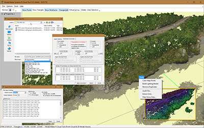
Virtual Survey Module
The software includes a sophisticated virtual survey module. This feature allows users to precisely extract and define selections of point cloud data. These curated data points can then be seamlessly transferred for use in Model Maker or other Digital Terrain Model (DTM) software, facilitating an integrated design and analysis workflow.
Filtering Capabilities
MMS Point Cloud 2023 integrates a powerful filtering module designed for meticulous data management. Users can leverage this tool for essential noise reduction, enhancing the overall quality of the point cloud. Furthermore, the filtering capabilities extend to data auditing by classname or a range of user-defined parameters, ensuring that only relevant and clean data proceeds to the modeling stages.
Data Compatibility and Export Options
To ensure broad usability and integration into existing project pipelines, MMS Point Cloud 2023 supports a variety of common data formats from different scanning devices. The software also provides flexible export functionalities, enabling users to output processed data in standard ASCII formats, thereby maximizing compatibility with other civil engineering and CAD applications.
Applications in the Surveying and Civil Engineering Fields
In the mining and construction sectors, MMS Point Cloud 2023 plays a vital role in projects requiring high-accuracy terrain modeling and site analysis. Professionals utilize its capabilities for tasks such as generating detailed topographical maps from laser scan data, monitoring site progress by comparing point clouds over time, and performing volumetric calculations for earthworks. The software’s ability to simplify complex data processing contributes to more efficient project planning and execution in these demanding fields.
Advantages of Using MMS Point Cloud 2023
MMS Point Cloud 2023 is distinguished by its user-centric design, which prioritizes ease of use and efficient performance, even on standard hardware configurations. Key advantages include the seamless integration of virtual survey tools with DTM software, advanced filtering for superior data quality, and support for diverse data formats. These attributes collectively contribute to a smoother and more productive workflow for professionals dealing with significant volumes of geospatial data.
Future Developments and Enhancements
The development roadmap for MMS Point Cloud 2023 includes plans for further enhancements to its feature set. Potential additions may involve new modules designed to expand its utility, such as specialized tools for CAD work creation. These future developments aim to further solidify the software’s position as a comprehensive solution for point cloud data processing in the surveying and civil engineering domains.
Comparative Analysis with Competing Tools
While specific direct comparisons are limited, MMS Point Cloud 2023 differentiates itself through its focused approach on simplifying point cloud data handling for terrain modeling applications. Unlike more general-purpose geospatial software, it emphasizes specialized modules like the virtual survey tool and efficient filtering capabilities. Its emphasis on user accessibility and hardware efficiency also positions it as a practical choice for surveying firms and construction companies seeking to manage complex datasets without requiring substantial investment in high-performance computing resources.
Frequently Asked Questions
What types of industries can benefit from using MMS Point Cloud 2023?
MMS Point Cloud 2023 is primarily aimed at industries such as mining, construction, and surveying where accurate terrain modeling is crucial. It enables professionals to easily handle and process large sets of geospatial data, supporting precise analysis and project planning.
How does the filtering module in MMS Point Cloud 2023 enhance data quality?
The filtering module allows users to remove noise and classify data based on user-defined parameters or by classname. This ensures that only high-quality, relevant data is used for subsequent analysis and modeling, thereby improving the accuracy of terrain models and other geospatial outputs.
What is the role of the virtual survey module in MMS Point Cloud 2023?
The virtual survey module allows users to extract selected data points from raw point cloud information for use in Model Maker or other DTM applications. This feature streamlines the workflow by enabling direct transfer of curated data, which is essential for efficient 3D terrain modeling.


Reviews
There are no reviews yet.