
Download 3D Space TopoLT 17.2 – Specialized Topography and Cadastral Mapping Add-On
3D Space TopoLT 17.2 is a specialized add-on designed to enhance the capabilities of CAD platforms like AutoCAD and IntelliCAD for professionals in civil engineering, geomatics, and land surveying. Developed by 3D Space, a company known for its geological and surveying software, TopoLT focuses on detailed topographical and cadastral mapping, providing essential tools for accurate land design and documentation.
Overview of TopoLT in Civil Engineering and Land Surveying
In civil engineering and land surveying, precise representation and documentation of land are critical. 3D Space TopoLT 17.2 serves as a powerful extension for industry-standard CAD software such as AutoCAD and IntelliCAD. This integration allows professionals to perform advanced cadastral mapping and detailed topographic design directly within their familiar CAD environments, streamlining workflows for land development, registration, and infrastructure projects.
Advanced Design Tools for 2D and 3D Land Feature Modeling
TopoLT offers a comprehensive suite of tools for the sophisticated design of land features in both two-dimensional and three-dimensional formats. Users can accurately model land parcels, delineate legal boundaries, and represent complex terrain characteristics. The software supports the creation of detailed topographical maps and 3D models, providing a robust platform for visualizing and planning land development projects.
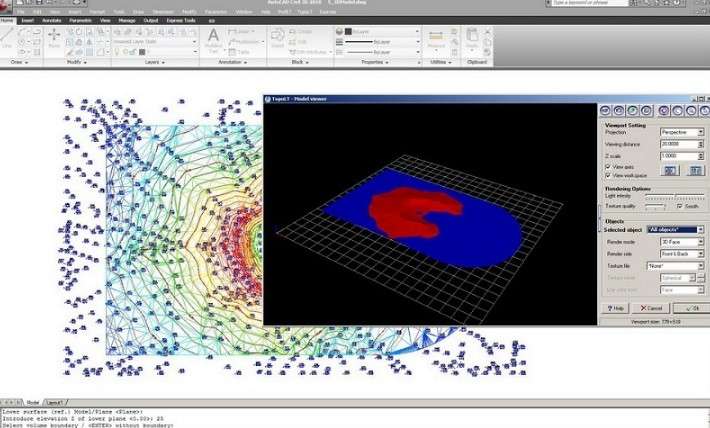
Precision Volume Calculation and Mapping for Construction Applications
For construction planning and earthworks, accurate volume calculations are paramount. 3D Space TopoLT 17.2 includes specialized functionalities for computing volumes based on 3D terrain models and land parcel designs. This feature enables civil engineers and surveyors to efficiently estimate quantities of materials needed for excavations or fill, supporting cost-effective project management and execution.
Integration with AutoCAD and IntelliCAD Platforms
Designed as an add-on plugin, TopoLT seamlessly integrates with established CAD platforms like AutoCAD and IntelliCAD. This integration means users can leverage its specialized topography and cadastral mapping tools without needing to switch to separate software. The add-on enhances the host CAD system’s functionality, providing a unified and efficient workflow for all land-related design and documentation tasks.
Customizable Settings and Project-Specific Workflows
Recognizing the diverse needs of surveying and engineering projects, 3D Space TopoLT 17.2 incorporates extensive customization options. Professionals can adjust software settings and recall specific configurations for different project types or client requirements. This adaptability optimizes workflows, increases productivity, and ensures that the software consistently meets the unique demands of various land surveying and cadastral mapping tasks.
Legal and Cadastral Mapping Capabilities
A key strength of TopoLT lies in its focused capabilities for legal and cadastral mapping. The software provides tools specifically designed for the precise demarcation of land boundaries and the creation of official land ownership maps. These outputs are crucial for legal documentation, land registry purposes, and ensuring compliance with surveying regulations, making TopoLT a valuable tool for cadastral surveyors.
Application Examples in Surveying and Engineering Projects
3D Space TopoLT 17.2 finds practical application across various real-world scenarios. Land surveyors utilize it for creating detailed topographic surveys and precise boundary plans for property transactions. Civil engineers rely on its volume calculation features for planning road construction, excavation projects, and site grading. Cadastral professionals employ its mapping tools for the creation and updating of legal land records and ownership documentation.
Frequently Asked Questions
What makes 3D Space TopoLT suitable for cadastral mapping compared to other CAD software?
3D Space TopoLT offers specialized tools tailored to cadastral mapping, such as precise boundary delineation, legal land parcel documentation features, and integration with surveying data, which general CAD software often lacks. This makes it more accurate and fit for official registry purposes.
How does TopoLT handle volume calculations for construction projects?
TopoLT provides precise volume calculation tools based on detailed 3D land feature modeling, allowing engineers to accurately estimate earthworks and material volumes needed for construction planning.
Is 3D Space TopoLT compatible with the latest versions of AutoCAD and IntelliCAD?
TopoLT is designed as an add-on compatible with multiple versions of AutoCAD and IntelliCAD, but users should verify compatibility with their specific CAD version to ensure seamless integration.


Reviews
There are no reviews yet.