
Download Simcore Seer3D 2.1.1 – Advanced 3D Visualization for Medical and Environmental Data
Simcore Seer3D 2.1.1 is a specialized application designed for advanced 3D visualization of field measurement data and groundwater model results. Developed for professionals in healthcare and environmental science, this software provides powerful tools for analyzing and presenting complex geospatial information. Its focus on scientific visualization makes it an essential tool for researchers and engineers working with detailed environmental and medical datasets.
Overview of Simcore Seer3D in Medical and Environmental Research
Simcore Seer3D is engineered to offer comprehensive 3D visualization for critical data in fields such as environmental science, groundwater hydrology, and medical research. It enables users to interpret complex datasets by rendering them in an intuitive three-dimensional space. This capability is particularly vital for understanding subsurface conditions and environmental impacts, offering insights that are often difficult to discern from 2D representations.
Visualization Capabilities and Data Presentation Features
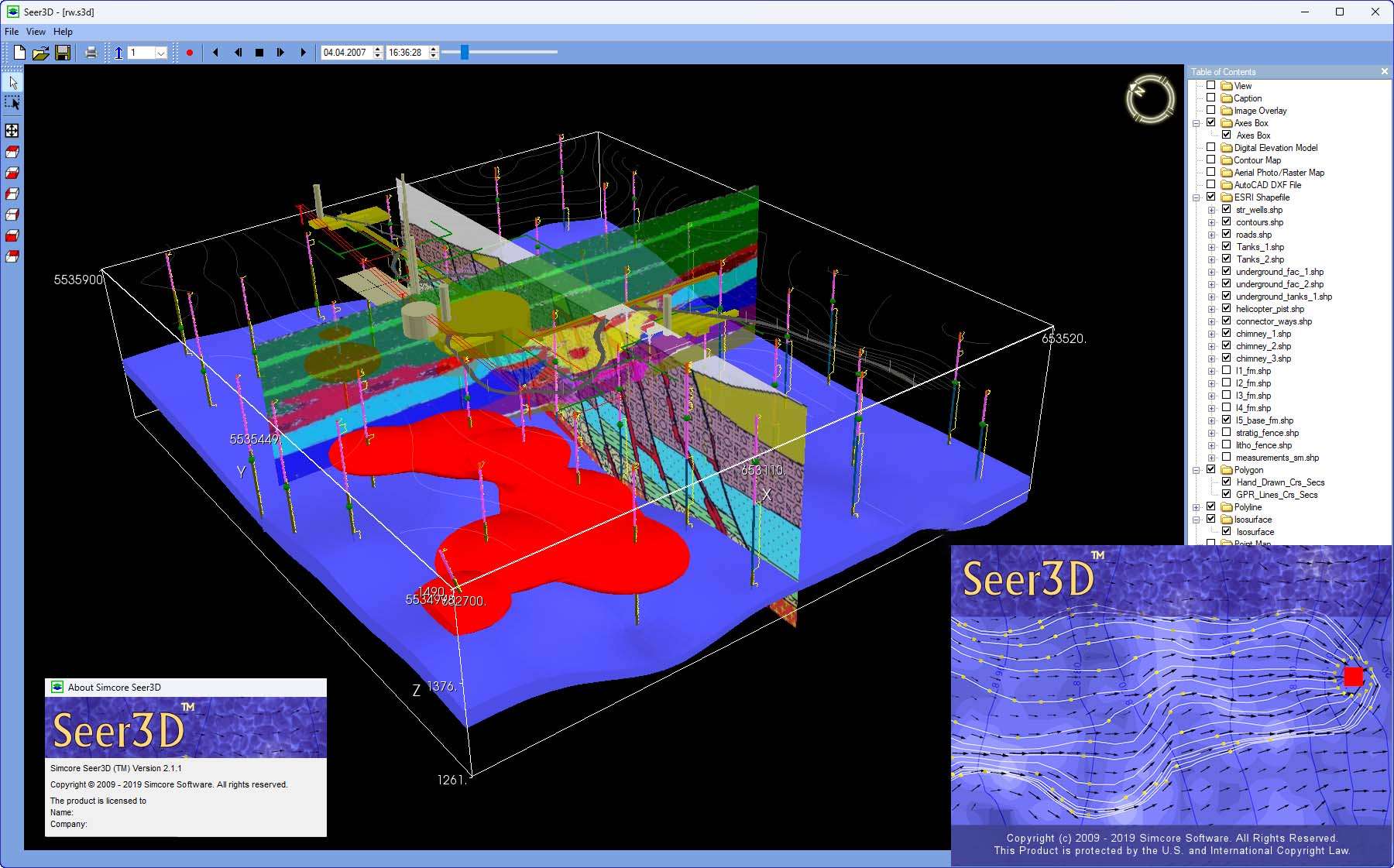
The software offers extensive capabilities for displaying diverse scientific data. Users can integrate various data formats into visually coherent scenes for detailed analysis and client presentations.
- Support for displaying vector and raster maps as base layers.
- Detailed visualization of wells, boreholes, and cross-sections.
- Rendering of lithological and geophysical data in 3D formats.
- Advanced controls for transparency, layering, and mesh or solid display options.
- Cropping tools allow users to focus on specific regions of interest within the 3D model.
- Tools for adding annotations, legends, and company logos to enhance context and branding.
Dynamic 3D Animations and Advanced Viewing Techniques
Simcore Seer3D excels in bringing dynamic environmental processes to life through advanced animation and viewing features, aiding in the understanding of temporal changes and spatial relationships.
- Animation capabilities for depicting the development of contamination plumes over time.
- Visualization of water level changes and flow vector fields in dynamic simulations.
- The “Advanced View” feature enables users to save and revisit specific 3D viewpoints for consistent analysis.
- Support for Quad buffered stereo technology provides an immersive stereoscopic 3D display, offering enhanced depth perception.
Supporting Professional Presentation and Data Sharing
Facilitating clear communication of complex findings to stakeholders is a core function of Simcore Seer3D, supported by its powerful presentation tools and a dedicated viewer.
The software can merge diverse data layers, including maps and complex simulation models, into a single, compelling 3D scene. This visual integration helps to clearly communicate findings to clients, colleagues, and regulatory bodies. Furthermore, Simcore Seer3D includes a free Seer3D viewer, allowing individuals without the full software license to interact with and review the created 3D models and animations, greatly enhancing collaboration and project delivery.
Applications and Use Cases in Medical and Environmental Fields
Simcore Seer3D provides tangible benefits across various scientific and engineering disciplines, offering practical solutions for complex data visualization challenges.
- Visualization of groundwater contamination plumes and remediation simulations in environmental studies.
- Analysis of hydrological data, including water table fluctuations and flow dynamics.
- Geospatial data analysis for environmental health and medical research projects.
- Representation of subsurface geological structures and geophysical survey results.
- Communication of model results to clients and project stakeholders for informed decision-making.
Researchers, hydrologists, environmental engineers, and healthcare professionals working with environmental impact studies can leverage Simcore Seer3D for more effective data interpretation and reporting.
Frequently Asked Questions
What types of data can Simcore Seer3D visualize?
Simcore Seer3D can visualize a wide range of data including vector and raster maps, wells, boreholes, lithological, and geophysical datasets related to groundwater and environmental fields. It is designed to handle complex geospatial and subsurface information for detailed 3D rendering.
How does Simcore Seer3D support 3D animations of environmental data?
The software allows creation of animation videos showing plume development, water level fluctuations, flow vector fields, and flow paths based on both measurement data and model results for enhanced dynamic visualization. These animations are crucial for understanding the temporal evolution of environmental processes.
Can I share my Seer3D visualizations with clients who do not have the software?
Yes, Simcore Seer3D provides a free Seer3D viewer which allows clients to view the 3D models and scenes you create without needing the full software, enhancing collaboration and presentation. This ensures that project findings can be easily shared and understood by all stakeholders.


Reviews
There are no reviews yet.