


Description
PCSWMM
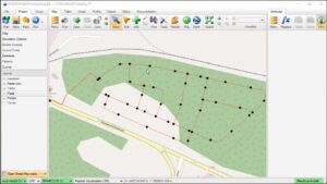
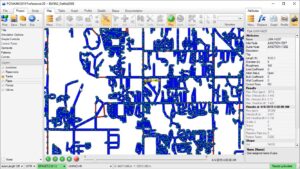
PCSWMM is the premier professional software for hydrologic and hydraulic (H&H) modeling of urban stormwater and wastewater collection systems. Built upon the powerful EPA SWMM5 engine, PCSWMM adds an advanced GIS-centric workflow, high-performance time-series data management, and unparalleled model building automation. Version 2025 v7.7 continues the software’s legacy of engineering excellence, offering enhanced 2D overland flow simulation, expanded climate change adaptation tools, and improved real-time control optimization. Whether designing new drainage infrastructure, evaluating flood mitigation strategies, managing combined sewer overflows (CSOs), or converting static models to real-time decision support systems, PCSWMM delivers the accuracy, scalability, and efficiency that modern water infrastructure projects demand.
🌊 Primary Users
This professional stormwater and wastewater modeling software is designed for:
-
Stormwater Engineers & Urban Drainage Planners designing and analyzing collection systems for urban catchments.
-
Wastewater Collection System Engineers modeling sanitary sewer networks and treatment plant inflows.
-
Floodplain Managers & Flood Control Professionals analyzing inundation extents and flood risk.
-
Environmental Engineers & Water Quality Specialists simulating pollutant transport and CSO/SSO impacts.
-
Municipal Utilities & Consulting Engineers developing master plans, rehabilitation strategies, and regulatory compliance reports.
⚡ Key Features & Capabilities
🌧️ Hydrologic (Rainfall-Runoff) Modeling
Rainfall-Runoff Methods:
-
Green-Ampt, Horton, and SCS Curve Number infiltration methods
-
Kinematic wave and nonlinear reservoir routing
-
Snowmelt modeling (temperature index method)
-
Continuous and single-event simulation
Climate Data Integration:
-
Design storms (historical, synthetic, probabilistic)
-
Continuous rainfall time series (5-minute to hourly)
-
Evapotranspiration (monthly average, time-series, Hargreaves)
-
Climate change multipliers for intensity and temperature
🏗️ Hydraulic (Flow Routing) Modeling
Conveyance Elements:
-
Open channels (natural & lined), closed conduits (circular, box, elliptical, arch)
-
Pipes (pressure, no pressure, partially full)
-
Pumps (on/off, variable speed, operational curves)
-
Orifices, weirs, outlets, regulators, and control structures
Flow Routing Methods:
-
Steady, kinematic wave, and dynamic wave routing
-
Full dynamic (St. Venant equations) for pressurized and backwater conditions
-
Surge analysis and pump station performance
-
Inlet capacity and bypass calculations
🌊 2D Overland Flow & Flood Mapping
2D Simulation:
-
Direct integration with EPA SWMM5 (no separate license)
-
2D overland flow on unstructured mesh (triangles/quads)
-
Interconnected 1D (conduit) + 2D (overland) simulation
-
Surface flooding extents, depth, velocity, hazard (depth × velocity)
Flood Hazard Mapping:
-
Floodplain delineation from 1D/2D results
-
Flow path, velocity, and depth mapping
-
Critical infrastructure flood risk assessment
-
HEC-RAS interoperability
🏙️ Sanitary Sewer Modeling
Wastewater Hydrology:
-
Dry weather flow (DWF) diurnal patterns (user-defined, built-in library)
-
Infiltration and inflow (I&I) – rainfall-dependent, groundwater
-
Sanitary sewer loading from population and land use
-
Commercial and industrial discharge patterns
Water Quality Simulation:
-
Pollutant buildup and wash-off (land use-based)
-
Constituent routing (BOD, TSS, TN, TP, bacteria, user-defined)
-
CSO and SSO event characterization
-
Treatment plant inflow prediction (hydrograph, pollutograph)
⚡ Real-Time Control (RTC)
RTC Rules:
-
If-Then-Else logic for gates, pumps, weirs, outlets
-
Sensor-driven control (flow, stage, water quality)
-
Time-based and scenario-based rule activation
Active RTC Optimization:
-
Multi-objective optimization (flood reduction, CSO minimization, energy savings)
-
Real-time forecast integration (radar, NWP)
-
Model Predictive Control (MPC)
🗺️ GIS-Centric Workflow
ArcGIS / QGIS Integration:
-
Direct editing of catchment, conduit, and node attributes
-
Topology checking and repair
-
Subcatchment delineation from DEM (automatic)
Map Display:
-
Thematic mapping by parameter (depth, velocity, flooding)
-
High-performance pan/zoom for millions of network elements
-
Pop-up query and edit in place
⚙️ Model Automation & Calibration
Model Builder & Scenario Manager:
-
Drag-and-drop creation calibration scenarios (parameter sets: roughness, infiltration, I&I)
-
Monte Carlo, Latin Hypercube, and Sobol sampling for uncertainty/Sensitivity
-
Automatic calibration using PEST (non-linear least squares, GLUE)
Time-Series Management:
-
Direct editing, visualization, and statistical analysis
-
Resampling and gap-filling tools
-
Import/export from SCADA, telemetry, and monitoring stations
📊 Optimization & Decision Support
Multi-Objective Optimization:
-
Genetic algorithm (NSGA-II) for trade-offs (flood depth vs. cost vs. water quality)
-
Optimal placement of green infrastructure
-
Low Impact Development (LID) sizing and placement
Performance Metrics:
-
Flood volume and duration, percent flooded nodes, surcharged links
-
CSO volume and frequency, water quality exceedances
-
Energy cost and pump efficiency
🆕 What’s New in Version 2025 v7.7
-
Climate Change Scenario Wizard – Automated downscaling and delta method for future climate (2040s, 2080s)
-
PEST++ Integration – Parameter estimation and uncertainty analysis (auto-calibration)
-
RTC-2D – Real-time control of gates/weirs in 2D overland flow domain
-
Enhanced LID Modeling – Blue roofs, permeable pavement, bioretention with underdrain control
-
Asset Management Dashboard – Condition-based inspection and rehabilitation prioritization (PACP, MACP, LACP)
-
Live Data Ingestion – Real-time telemetry (SCADA, radar rainfall) for nowcasting and warning
-
Native Cloud Engine – Run 1000+ Monte Carlo scenarios on AWS/Azure in hours
-
GPU Acceleration – Up to 10× speedup for 2D flood simulations (NVIDIA CUDA)
🎯 Industry Applications
-
Municipal Stormwater Master Planning – Capacity analysis, flood mitigation, green infrastructure, climate resilience
-
Sanitary Sewer Collection System – I&I reduction, CSO/SSO control, capacity assurance, rehabilitation prioritization
-
Floodplain & Flood Hazard Management – Inundation mapping, flood risk analysis, warning systems
-
Regulatory Compliance – NPDES, MS4, Combined Sewer Overflow (CSO) long-term control plan (LTCP)
-
Real-Time Decision Support – Flood warning, pump station optimization, smart city integration


Reviews
There are no reviews yet.