
Download EIVA NaviEdit 9.1 – Marine Survey Navigation and Sensor Data Editor
EIVA NaviEdit 9.1 is a specialized application designed for editing and processing navigation and sensor data collected during marine surveys. Developed by EIVA, a Danish company known for its marine engineering software solutions, this tool is essential for professionals in hydrography, offshore engineering, and geophysical data processing. It facilitates the precise handling of data streams from multiple marine survey sensors, ensuring high-quality geospatial and bathymetric datasets.
Overview and Applications in Marine Surveying
EIVA NaviEdit serves as a critical component in the marine survey workflow, enabling users to refine raw data acquired from various underwater and surface sensors. Professionals such as hydrographers, offshore engineers, and geophysical data analysts rely on this software to prepare complex datasets for subsequent analysis and interpretation. Its primary applications involve ensuring the accuracy and integrity of information gathered during seabed mapping, resource exploration, and offshore infrastructure surveys.
Advanced Multi-Sensor Visualization and Data Synchronization
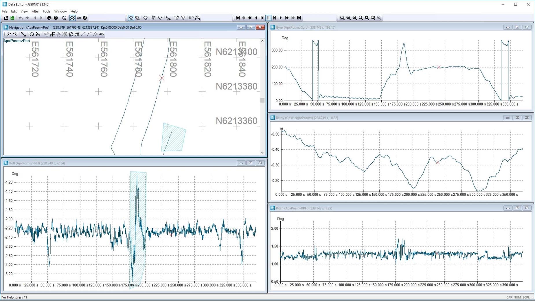
The software provides advanced capabilities for visualizing synchronized timelines of multiple sensor data streams. This includes the seamless integration and display of positioning data from GNSS and LBL systems, heading information from gyrocompasses, depth readings from echosounders, and data from specialized survey sensors like multibeam echosounders and side-scan sonars. By presenting these diverse data types on a synchronized timeline, NaviEdit allows users to identify discrepancies and ensure that all sensor observations are correctly time-stamped and aligned.
Techniques for Data Filtering, Calibration, and Trajectory Correction
EIVA NaviEdit 9.1 offers a suite of sophisticated tools for data refinement. Users can effectively remove erroneous data points using advanced filtering algorithms, apply precise time delay corrections to account for clock synchronization issues between sensors, and calibrate lever arm offsets to accurately represent the relative positions of different sensors on the survey vessel. Furthermore, the software excels at reconstructing and editing vessel trajectories, ensuring reliable positioning information even when primary navigation data sources are temporarily lost or degraded.
Integration with Inertial Navigation and Post-Processing Systems
A key differentiator for NaviEdit is its robust integration with inertial navigation systems (INS) and GNSS post-processing software. Version 9.1 specifically enhances connectivity with leading INS solutions such as POSPac and Inertial Explorer. This integration allows for the import and processing of highly accurate navigation solutions derived from these systems, enabling users to achieve unparalleled precision in their collected survey data and correct trajectories with advanced algorithms.
Export Formats and Workflow Compatibility
EIVA NaviEdit supports flexible data export options, ensuring seamless integration into broader marine survey workflows. The software can export processed and synchronized data in industry-standard ASCII formats, as well as in EIVA’s proprietary .nvi format. This compatibility is crucial for downstream processing in other EIVA NaviSuite modules, including NaviModel for 3D seabed modeling and NaviScan for survey planning and execution, facilitating an efficient end-to-end data management process.
Performance Enhancements and User Interface Improvements in Version 9.1
Version 9.1 of EIVA NaviEdit introduces several significant improvements aimed at enhancing user experience and processing efficiency. The update focuses on an improved user interface offering better performance and responsiveness, particularly when handling large datasets typical in modern marine surveys. Expanded sensor model support and enhanced batch processing capabilities further streamline complex quality control operations and project management for marine survey professionals.
Real-World Use Cases in Hydrography and Offshore Surveys
NaviEdit is routinely applied in critical marine survey applications. Hydrographic professionals use it to clean and prepare multibeam echosounder and GNSS data before generating detailed seabed maps. In offshore engineering, it is vital for correcting navigation data during pipeline inspections to ensure accurate location of subsea assets. Additionally, ROV (Remotely Operated Vehicle) survey data, including sensor feeds and navigation, can be synchronized and edited for detailed subsea inspections and asset integrity assessments.
Frequently Asked Questions
What types of sensor data can EIVA NaviEdit 9.1 process and synchronize?
EIVA NaviEdit 9.1 is built to process and synchronize data from a wide array of marine survey sensors. This includes crucial instruments such as multibeam echosounders, side-scan sonars, and sub-bottom profilers for acoustic imaging, alongside positioning systems like GNSS, USBL, and LBL navigation sources. This comprehensive multi-sensor integration is fundamental to ensuring accurate marine survey data correction and analysis.
How does NaviEdit improve navigation data accuracy in marine surveys?
NaviEdit significantly enhances navigation data accuracy by employing sophisticated techniques. It provides advanced filtering capabilities to identify and remove erroneous data points, applies precise time delay corrections to synchronize sensor clocks, and calibrates lever arm offsets between different sensors. The software also excels at reconstructing and editing vessel trajectories, leading to more reliable positioning information throughout the survey.
Can EIVA NaviEdit integrate with other software for further survey data processing?
Yes, EIVA NaviEdit is designed for seamless integration into existing marine survey workflows. It exports cleaned and corrected navigation data in versatile formats such as ASCII and the proprietary .nvi, which are compatible with other EIVA NaviSuite modules like NaviModel and NaviScan, as well as various third-party software solutions. Furthermore, it maintains tight integration with GNSS/INS post-processing software, including industry standards like POSPac and Inertial Explorer.


Reviews
There are no reviews yet.