
Download Geological Evaluation System 22 – Advanced Geological Data Analysis & 3D Modeling
Geological Evaluation System 22 (GES22) is an advanced software application designed for comprehensive geological data analysis and 3D subsurface modeling. Developed for professionals in the oil & gas exploration and production, mining, and geotechnical research sectors, GES22 facilitates detailed interpretation of subsurface data, enabling precise resource estimation and visualization of geological structures.
Overview of GES22 in Oil & Gas and Mining Exploration
GES22 provides a unified workflow critical for modern exploration and resource management. This version builds upon established geoscience methodologies, offering enhanced capabilities for geologists, reservoir engineers, and mining geologists. Its primary purpose is to translate raw geological data into actionable insights, supporting informed decision-making in complex subsurface environments.
Data Processing and Interpretation Capabilities
Well-Log Data Analysis
The software facilitates the import and analysis of well-log data, primarily through the industry-standard LAS format. Users can perform detailed curve editing, data conditioning, and lithology interpretation to understand the vertical rock sequences encountered in boreholes.
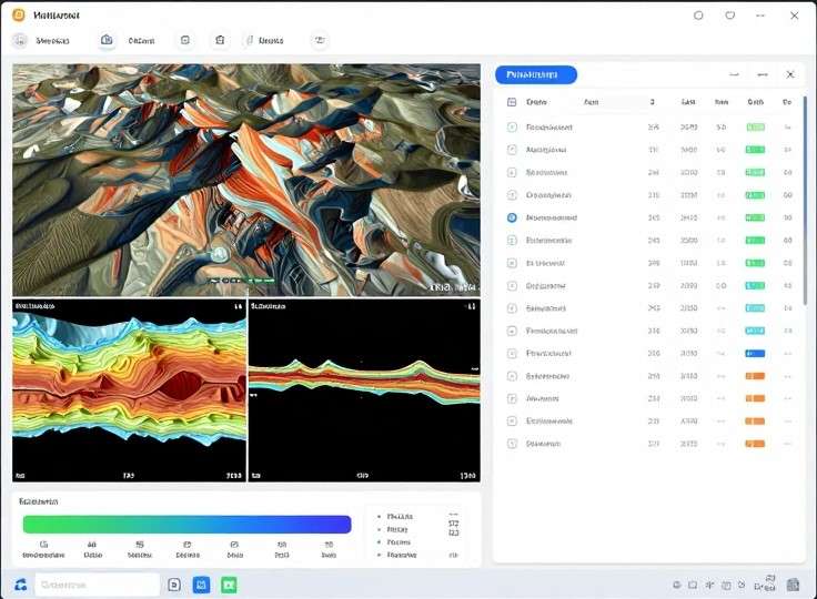
Seismic Data Interpretation
GES22 supports the interpretation of seismic data, commonly handled in the SEG-Y format. Capabilities include horizon picking to delineate key geological markers, fault identification for structural analysis, and the generation of seismic attributes to infer subsurface properties.
3D Geological Modeling and Visualization
GES22 offers robust tools for constructing high-precision 3D geological models of the subsurface. This involves creating volumetric grids (voxels) or structural frameworks composed of surfaces and stratigraphic layers. Users can generate detailed cross-sections and arbitrary 3D views to visualize complex geological relationships.
Resource Estimation and Geostatistics
Volumetric Calculations
Essential for mineral and hydrocarbon reserve assessment, GES22 enables precise volumetric calculations. The software supports the estimation of resources to varying confidence levels, including P90, P50, and P10 reserves, vital for financial reporting and project viability studies. It may also incorporate material balance methods for reservoir analysis.
Geostatistical Techniques
Advanced geostatistical techniques are integrated within GES22 to model spatial variability and quantify uncertainty. This includes variogram modeling to understand data continuity, and various kriging methods (e.g., ordinary kriging, indicator kriging) for interpolating data and estimating properties across the model domain.
Integration with GIS and CAD Platforms
To ensure seamless integration within broader project workflows, GES22 supports interoperability with Geographic Information System (GIS) and Computer-Aided Design (CAD) platforms. It handles common data formats such as shapefiles for spatial data and DXF for CAD drawings, adhering to OGC standards where applicable.
Real-World Case Studies
GES22 is applied in diverse geological evaluation scenarios. Specific use cases include detailed reservoir characterization in oilfields to identify potential hydrocarbon zones, evaluation of mineral deposits for prospecting and reserve definition, and complex subsurface modeling for academic research projects analyzing geological phenomena.
Extending GES22 with Plugins and Scripting
The functionality of GES22 can be extended through available APIs, supporting custom algorithm integration and workflow automation. Users may leverage scripting languages such as Python or MATLAB to develop custom analysis routines or to tie GES22 into other specialized software environments.
Frequently Asked Questions
What file formats does Geological Evaluation System 22 support?
GES22 supports industry-standard formats including LAS for well logs, SEG-Y for seismic volumes, shapefiles for GIS data, and DXF for CAD interoperability, enabling seamless data exchange within geological workflows.
How does GES22 perform resource estimation and uncertainty analysis?
GES22 uses geostatistical techniques such as ordinary and indicator kriging combined with variogram modeling to calculate P90, P50, and P10 volumetric estimates, providing quantified uncertainty intervals for reserve classification.
Can GES22 integrate with ArcGIS or other GIS platforms?
Yes, GES22 exports and imports shapefiles and OGC-compliant data layers, allowing direct integration with ArcGIS, QGIS, and other GIS environments for mapping and spatial analysis.


Reviews
There are no reviews yet.