Download GEOS Geodepl 2025 – Settlement Monitoring Software for Geotechnical Analysis
GEOS Geodepl 2025 is a specialized geotechnical settlement monitoring software designed for civil and geotechnical engineers. It is crucial for assessing and predicting soil settlement behavior, a critical factor in the safety and performance of infrastructure projects. This software aids professionals in managing complex data to ensure accurate analysis of consolidation, which is fundamental to sound foundation design and construction monitoring.
Overview of GEOS Geodepl 2025 in Geotechnical Settlement Monitoring
In civil engineering, understanding and predicting soil settlement is paramount for the long-term stability of structures. GEOS Geodepl 2025 addresses this need by providing advanced tools for geotechnical settlement monitoring. The software facilitates the detailed analysis of soil consolidation, enabling engineers to forecast how structures will behave over time under various load conditions. This capability is essential for mitigating risks associated with differential settlement, which can compromise the integrity of buildings, bridges, and other infrastructure.
Advanced Calculation Methods Integrated in GEOS Geodepl
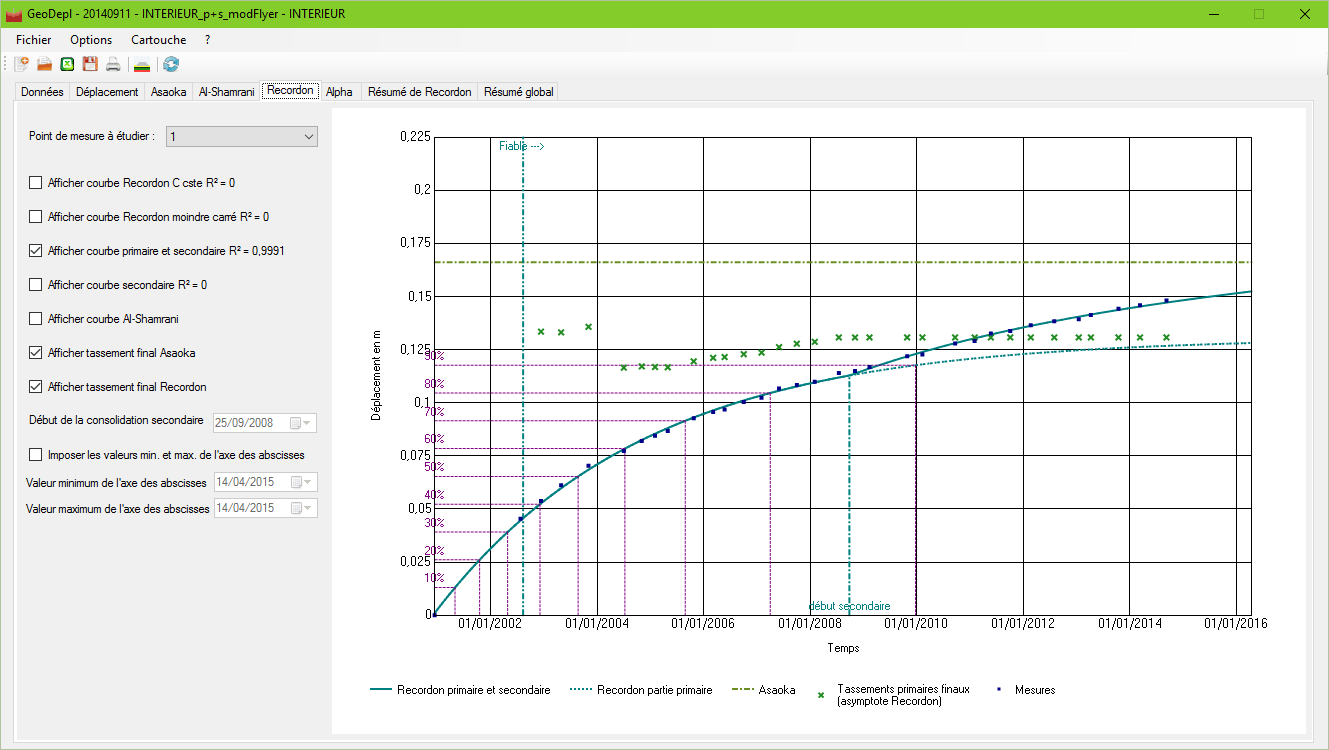
GEOS Geodepl 2025 integrates several established methodologies for calculating different phases of soil settlement. It is equipped to analyze primary settlement, which occurs due to the expulsion of pore water under load, and secondary settlement (or creep), which happens after the primary consolidation is complete. The software implements well-regarded methods for prediction, including Asaoka’s method, Recordon’s method, and Al-Shamrani’s method. These tools allow for the estimation of settlement amplitudes, the prediction of consolidation percentages, and the calculation of crucial parameters like the vertical consolidation coefficient (Cv).
Data Input and Reference Point Management Features
Effective settlement monitoring requires managing data from multiple locations. GEOS Geodepl 2025 streamlines this process by allowing users to input data from numerous benchmark points. This can be done directly through the interface or via imported spreadsheets, catering to various data handling preferences. The software provides robust tools for navigating through these different measurement points, enabling selective data deactivation for focused analysis on specific areas or timeframes. This feature is vital for understanding spatial variations in settlement across a project site.
Output Summaries and Interpretation Aids
Upon completing its analysis, GEOS Geodepl 2025 provides comprehensive output summaries to aid engineers in interpreting the results. These outputs include definitive final settlement amplitudes for each monitored point, estimates of the vertical consolidation coefficient (Cv), and analysis of settlement changes over time. The software presents this data in both graphical and tabulated formats, offering clear visualizations of settlement progression and patterns. Such detailed reporting is essential for performance assessments and for making informed decisions regarding construction adjustments or long-term monitoring strategies.
Applications and Use Cases in Civil Engineering Projects
The capabilities of GEOS Geodepl 2025 are directly applicable to a wide range of civil engineering projects. Geotechnical engineers utilize this software for crucial tasks such as predicting settlement beneath new foundations for buildings and bridges, monitoring the consolidation of soil under newly constructed embankments, and assessing the long-term stability of earth dams. In infrastructure development, it plays a key role in overseeing the performance of tunnels, roadways, and other large-scale constructions, ensuring that settlement remains within acceptable engineering tolerances and identifying potential issues before they become critical.
Integration Potentials and Compatibility with Civil Engineering Workflows
While GEOS Geodepl 2025 is a specialized tool, its outputs can integrate into broader civil engineering workflows. The software is designed to export data in standard formats, facilitating its use in conjunction with other geotechnical analysis software or project management platforms. This interoperability allows engineers to incorporate settlement monitoring results into comprehensive project reports, design reviews, and risk assessments. Optimized data exchange ensures that settlement analysis is seamlessly woven into the overall engineering process, contributing to more efficient project delivery and enhanced structural safety.
Frequently Asked Questions
How does GEOS Geodepl 2025 improve the accuracy of settlement predictions compared to manual methods?
GEOS Geodepl 2025 utilizes established empirical methods such as Asaoka’s, Recordon’s, and Al-Shamrani’s that mathematically model primary and secondary settlement phases. Automation and the ability to process data from multiple benchmark points significantly reduce the potential for human error inherent in manual calculations, thereby improving the reliability and accuracy of settlement predictions.
Can GEOS Geodepl handle multiple settlement measurement points and how is this managed?
Yes, the software is designed to handle multiple settlement measurement points. Users can input data from several reference points directly into the software or import it via spreadsheets. The interface allows for easy navigation between these measurement points and provides options to selectively analyze specific data segments, enabling more refined and detailed evaluations for complex project sites.
What are the typical engineering projects that benefit from using GEOS Geodepl 2025?
Projects that critically require precise settlement monitoring and prediction benefit greatly from GEOS Geodepl 2025. This includes foundation settlement analysis for buildings and bridges, embankment construction monitoring, earth dam performance assessment, and various other infrastructure development projects where understanding soil consolidation and settlement is vital for safety and longevity.


Reviews
There are no reviews yet.