
Download MagLog 2024 v3.43 – Geophysical Data Logger Software
MagLog 2024 v3.43 is a specialized data logging software designed for geophysical survey applications. Developed to handle serial data streams, it provides essential tools for professionals conducting land, marine, and airborne surveys. The software is engineered to offer robust data handling, real-time monitoring, and precise time synchronization, crucial for maintaining the integrity and usability of gathered geophysical data.
Overview of MagLog 2024
Introduction to Data Logging in Geophysics
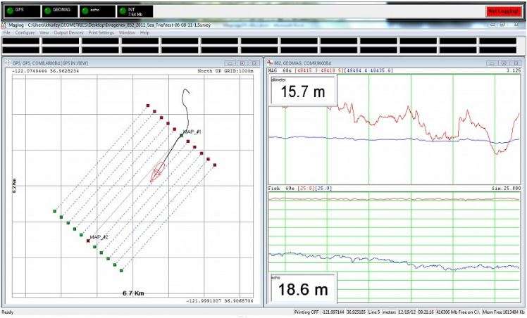
Accurate data logging is fundamental to geophysical surveys, serving as the bedrock for analysis and interpretation of subsurface geological and environmental conditions. Geophysical data logger tools must reliably capture information from diverse sensor types, ensuring that each data point is precisely timed and validated. MagLog 2024 addresses these critical requirements, offering specialized functionalities to manage and display serial data streams from various geophysical instruments.
Key Versions: MagLogPro™ vs MagLogLite™
MagLog is offered in two distinct versions, catering to a spectrum of user needs and project complexities:
- MagLogPro™: This advanced version is engineered for complex geophysical projects, supporting multi-sensor applications and providing comprehensive data logging capabilities for sophisticated survey setups. It is ideal for scenarios requiring the integration of numerous data streams.
- MagLogLite™: Designed for simpler logging requirements, MagLogLite is suitable for single or dual sensor configurations. It offers essential data logging and QC features, making it an effective solution for less complex surveys, including archaeological investigations.
Main Features of MagLog 2024
Real-Time Quality Control
MagLog 2024 integrates robust real-time quality control (QC) features. This capability allows users to monitor incoming serial data streams as they are acquired, enabling immediate validation of data integrity and sensor performance. This proactive approach to data QC is vital for ensuring that survey data remains accurate and reliable throughout the collection process.
Accurate Time Stamping
Precise temporal data is crucial in geophysical surveys for correlating information from different sensors and for subsequent analysis. MagLog 2024 excels in providing accurate time stamping for all logged data. This ensures that each data point is associated with an exact timestamp, facilitating precise synchronization and integration with other surveyed information.
User Help Features
To streamline the data ingestion process and assist users in managing incoming data, MagLog 2024 includes comprehensive user-help features. These tools are designed to simplify the configuration and operation of the software, particularly when dealing with various serial data streams, helping users effectively manage their data collection workflows.
Applications in Geophysical Surveys
MagLog 2024 is versatile and applicable across a range of geophysical survey types and environments. Its ability to handle diverse sensor inputs makes it a valuable tool for professionals in the field:
- Marine Magnetometry: The software is well-suited for processing data from marine magnetometers, essential for subsurface geological mapping and resource exploration in aquatic environments.
- Multi-Sensor Arrays: Both MagLogPro and MagLogLite can manage data from multiple sensors, which is critical for comprehensive surveys requiring the simultaneous collection of various geophysical parameters.
- Land and Airborne Surveys: The software supports data logging for land-based geophysical investigations and airborne surveys, adapting to different operational platforms and environmental conditions.
- Archaeological Surveys: As supported by MagLogLite, the software can be employed in archaeological contexts for detecting subsurface anomalies using geophysical methods.
Compatibility and Integration
A key strength of MagLog 2024 is its capacity to log data directly from various sensors via serial ports. This capability eliminates the need for additional specialized hardware, simplifying survey setups. The software is designed to integrate seamlessly with common instruments used in geophysical fieldwork, ensuring broad compatibility for professionals utilizing diverse equipment portfolios.
Conclusion
For geophysical professionals requiring reliable, precise, and manageable data logging solutions, MagLog 2024 v3.43 presents a robust option. Its specialized versions, MagLogPro™ and MagLogLite™, along with core features like real-time QC and accurate time stamping, support efficient and dependable data acquisition across a wide array of geophysical survey applications.
Frequently Asked Questions
What types of sensors can be used with MagLog?
MagLog supports a variety of external instruments for data logging, making it suitable for multi-sensor arrays in both land and marine geophysical surveys. This flexibility allows users to connect and log data from different types of geophysical sensors commonly used in the field.
How does MagLog ensure data integrity during surveys?
MagLog features real-time quality control and accurate time stamping, ensuring that all logged data is monitored and precisely recorded as it arrives. These functionalities are crucial for maintaining the accuracy and reliability of geophysical measurements throughout the survey.
Can MagLog be used for archaeological surveys?
Yes, MagLog is suitable for archaeological surveys, especially with its MagLogLite version, designed for simpler applications like single or dual sensor logging. This version offers the necessary data capture and management features for detecting subsurface anomalies in archaeological contexts.


Reviews
There are no reviews yet.