
Download MMS Model Maker 2023 – Advanced Digital Terrain Modeling Software
MMS Model Maker 2023 is an advanced digital terrain modeling software developed by Model Maker Systems, specifically designed for professionals in the geospatial analysis, civil engineering, and surveying fields. This application focuses on creating accurate digital terrain models (DTMs) from various data sources, supporting complex civil engineering projects and detailed terrain analysis. Its capabilities make it a vital tool for geomatics professionals and civil engineers involved in infrastructure planning and construction.
Overview of MMS Model Maker 2023
Introduction to Terrain Modeling
Terrain modeling is a critical process in civil engineering and surveying that involves creating digital representations of the Earth’s surface. These models are essential for understanding topography, planning construction, analyzing environmental impacts, and managing land resources effectively. Accurate terrain modeling software allows professionals to visualize landscapes, calculate volumes, and design infrastructure with precision, reducing risks and optimizing project outcomes.
Key Features and Capabilities
MMS Model Maker 2023 offers a comprehensive suite of tools for digital terrain modeling, equipped to handle diverse project requirements. Its functionality spans the entire workflow from data ingestion to final output generation.
- Data Input: Supports various data formats, including ASCII formats, enabling users to import data from a wide range of surveying instruments and geomatics sources.
- Data Editing and Processing: Features advanced algorithms for data cleaning, filtering, and manipulation, ensuring that raw survey data is refined into a usable format for modeling. This includes specialized triangulation routines that automatically reduce survey data.
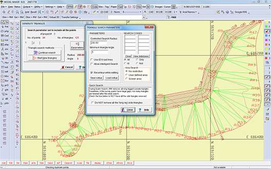
- Triangulation and DTM Generation: Utilizes sophisticated triangulation methods to convert x, y, and z coordinate data into a precise Digital Terrain Model. The software also provides options for validating the generated model against original observation records to ensure peak data accuracy.
- Surface Analysis: Offers tools for calculating surface properties, such as slope, aspect, and curvature, which are vital for site analysis and planning in civil engineering projects.
- Volume Calculations: Provides accurate tools for calculating earthwork volumes, essential for cost estimation and material management in construction and mining applications.
- Output and Visualization: Generates detailed 3D visualizations and allows for the export of terrain models in multiple formats compatible with CAD and GIS software.
Modular Design and Accessibility
A key differentiator of MMS Model Maker 2023 is its modular design, allowing users to select and pay for only the functionalities they need. This approach provides significant benefits, particularly in terms of cost efficiency and customization.
- Customized Functionality: Users can build a software package tailored to their specific project requirements, whether it’s basic terrain modeling or advanced geospatial analysis.
- Cost-Effectiveness: By offering a modular structure, Model Maker Systems makes advanced terrain modeling capabilities accessible without requiring users to invest in comprehensive software suites they may not fully utilize.
- Scalability: The modular architecture allows users to add new modules as their project needs or business requirements evolve, providing a scalable solution that grows with their capabilities.
Applications in Civil Engineering and Surveying
MMS Model Maker 2023 has broad applicability across various professional domains, supporting complex projects from initial planning through to execution.
- Construction Site Modeling: Used for generating detailed digital terrain models of construction sites, facilitating accurate site planning, earthwork calculations, and progress monitoring.
- Civil Infrastructure Planning: Supports the design of roads, bridges, and other infrastructure by providing terrain data for route optimization, cut and fill analysis, and drainage studies.
- Geospatial Analysis for Mining: Applied in the mining industry for terrain analysis, reserve estimation, and planning excavation activities, ensuring efficient resource management and operational safety.
- Land Surveying and Mapping: Assists surveyors in creating precise topographic maps and DTMs from field data, essential for land development and boundary surveys.
Interoperability with Other Software
To ensure seamless integration into existing professional workflows, MMS Model Maker 2023 offers extensive compatibility with popular design and analysis software. This feature is crucial for project efficiency and data consistency across different platforms.
- File Format Compatibility: Supports a wide array of industry-standard file formats, including DXF and DWG, facilitating data exchange with various CAD systems. It also handles common ASCII formats for broader data import capabilities.
- CAD Integration: Enables users to import and export terrain models directly into and from leading CAD applications, streamlining the design process and reducing manual data conversion steps.
- GIS Workflow Support: Its ability to work with common geospatial data formats ensures that the terrain models created can be readily used in Geographic Information System (GIS) workflows for further analysis and management.
Conclusion and Future Developments
MMS Model Maker 2023 stands as a robust and adaptable solution for digital terrain modeling, offering professionals in civil engineering and surveying powerful tools for geospatial analysis and project planning. Its unique modular design, combined with extensive CAD interoperability, enhances efficiency and cost-effectiveness. Model Maker Systems continues to develop its software, aiming to incorporate emerging technologies and user feedback to further advance its capabilities in digital terrain modeling and geomatics.
Frequently Asked Questions
What types of projects can MMS Model Maker 2023 be used for?
MMS Model Maker 2023 is ideal for a range of projects in civil engineering, including terrain modeling for construction, site planning, and geospatial analysis. Its modular design allows for tailored applications based on user needs, supporting everything from preliminary site assessments to detailed infrastructure planning.
How does MMS Model Maker ensure data accuracy during modeling?
The software incorporates robust triangulation routines that automatically reduce survey data to x, y, and z coordinates, ensuring data accuracy and providing options for validation against original observation records. This meticulous approach guarantees precise digital terrain models essential for critical engineering applications.
Can MMS Model Maker 2023 integrate with other CAD software?
Yes, MMS Model Maker is compatible with various file formats including DXF, DWG, and others, allowing seamless integration with popular CAD applications, which enhances workflow and project efficiency. This broad compatibility ensures that users can easily incorporate Model Maker into their existing design and drafting environments.


Reviews
There are no reviews yet.