
Download MMS Survey Maker 2023 – Specialized Surveying Software
MMS Survey Maker 2023 is a specialized surveying software developed by Model Maker Systems, designed to address a wide range of needs within the land surveying, engineering surveying, mining surveying, geodetic surveying, and hydro-surveying fields. This robust application offers user-friendly data input and comprehensive calculation capabilities, making it an essential tool for professionals seeking efficiency and accuracy in their daily tasks.
Overview of MMS Survey Maker 2023
Introduction to the software
MMS Survey Maker 2023 serves as a critical application for surveyors, providing essential tools for data collection, processing, and analysis. Its utility spans across diverse surveying disciplines, offering solutions for complex calculations and plan generation. The software is important in the field for its ability to streamline workflows and enhance the precision of survey outcomes, supporting professionals in delivering accurate geospatial data for various projects.
History and Development Background
Developed by Model Maker Systems, the ethos behind MMS Survey Maker 2023 emphasizes practicality and user-centric design. While specific historical details of the company are limited, their focus has consistently been on creating dependable software solutions tailored to the evolving demands of the surveying and civil engineering industries. This commitment drives the development of robust modules that cater to specialized professional requirements.
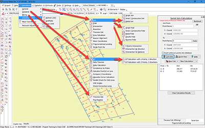
Key Features and Modules
Basic Survey Calculations
MMS Survey Maker 2023 simplifies fundamental survey calculations through both manual and digital input methods. The software provides accessible tools for a variety of essential computations, ensuring that surveyors can efficiently process their field data. This feature is critical for foundational survey work, enabling quick and accurate results.
Cadastral Functions and Generating Plans
The software incorporates crucial cadastral functions that are significant in professional surveying practices. These tools assist in defining property boundaries accurately and generating the precise documentation required for land registration and legal purposes. The ability to produce reliable cadastral plans is a key aspect of its utility for land surveying professionals.
Field Book Reduction Techniques
MMS Survey Maker 2023 offers detailed methodologies for reducing leveling data collected in the field. This capability allows surveyors to accurately process readings from leveling instruments, converting them into usable elevation data. Such techniques are vital for topographic surveys, construction projects, and infrastructure development where precise height information is necessary.
Specific Functions for Mine Surveying
Tailored for the unique demands of the mining industry, MMS Survey Maker 2023 includes specialized functions for mine surveying. These tools support subsurface mapping, volume calculations, and monitoring of mine structures. Professionals in mining operations benefit from these dedicated features to ensure safety and operational efficiency.
Datum Conversion and Coordinate Systems
This surveying software provides robust data transformation features, enabling seamless conversion between different datum and coordinate systems. This is essential for integrating survey data from various sources or complying with regional mapping standards. The accuracy of these transformations is crucial for large-scale engineering and geodetic projects.
Sectional Title Drawings Automation
MMS Survey Maker 2023 streamlines the complex process of generating Sectional Title Plans. These plans are vital for subdividing buildings into individual units. The software’s automated capabilities reduce the time and effort required for this detailed work, enhancing productivity for property development and management professionals.
Real-World Applications of MMS Survey Maker 2023
MMS Survey Maker 2023 finds extensive application across various professional domains. In land surveying, it is used for boundary demarcation, topographic mapping, and preparing cadastral plans for property registration. For engineering projects, it supports detailed site surveys, infrastructure planning, and volumetric analysis for construction. In the mining sector, professionals utilize its specific tools for geological mapping, mine planning, and monitoring ground movement. Geodetic surveying benefits from its precise coordinate system handling and datum conversion capabilities, while hydro-surveying can leverage its data processing features for mapping underwater terrains.
Comparison with Other Surveying Tools
Compared to generic CAD software, MMS Survey Maker 2023 offers specialized modules and workflows specifically designed for surveying tasks. While other surveying programs might focus on a broad suite of geospatial tools, MMS Survey Maker distinguishes itself through its emphasis on user-friendly data input and a comprehensive set of calculation tools grouped into customizable modules. Its particular strength lies in simplifying complex survey calculations and automating tasks like sectional title drawing generation, which may require more manual effort in less specialized applications.
Conclusion
MMS Survey Maker 2023 stands as a vital piece of civil engineering software for professionals engaged in diverse surveying disciplines. Its combination of robust calculation capabilities, specialized modules for land and mine surveying, and user-friendly interface makes it an indispensable tool for accuracy and efficiency. For anyone involved in land surveying program tasks, survey calculations, or requiring advanced land surveying tools, MMS Survey Maker 2023 offers a comprehensive and reliable solution.
Frequently Asked Questions
What types of surveys can MMS Survey Maker 2023 assist with?
MMS Survey Maker 2023 is designed to aid in various types of surveys including land, engineering, mining, geodetic, and hydro-surveys, offering specialized functions tailored to each type. Its modular design ensures that professionals in each field can utilize a dedicated set of tools appropriate for their specific project requirements.
How does MMS Survey Maker simplify survey calculations?
The software provides a user-friendly interface that allows input of survey points either manually or through data import, streamlining the process of conducting various survey calculations. This approach minimizes errors and accelerates the typically time-consuming process of data computation for different surveying scenarios.
Are there any features in MMS Survey Maker specifically for mining surveys?
Yes, MMS Survey Maker includes specific functions dedicated to mine surveying, making it easier for professionals to handle the unique challenges in this field. These mining surveying tools can cover tasks such as calculating volumes, mapping underground structures, and monitoring surface stability.


Reviews
There are no reviews yet.