
Download NeuraMap 2021.12 – Automated Map Digitizing Software
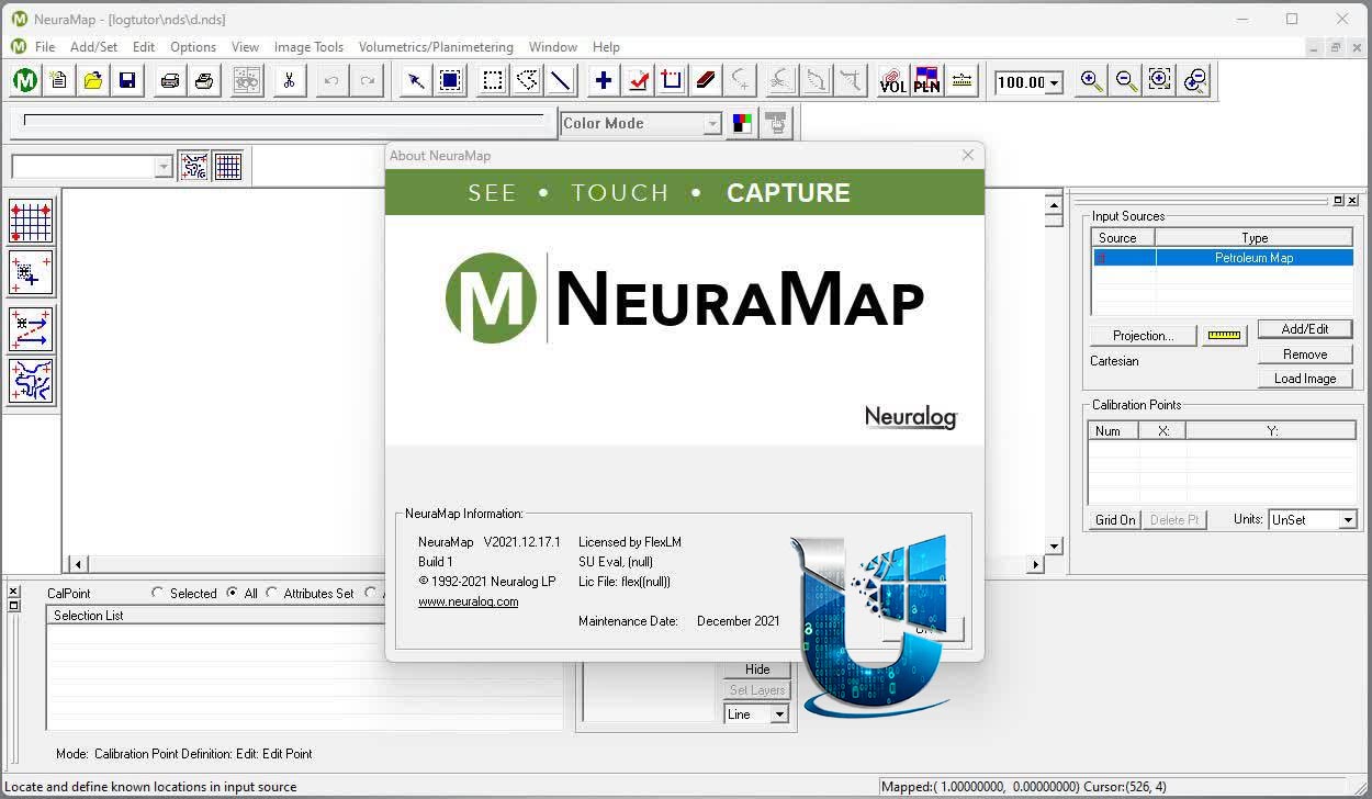
NeuraMap is a specialized digital mapping software developed by Neura, designed to automate the process of digitizing paper maps for geoscientists and professionals in the oil and gas exploration industry. This tool is crucial for efficiently capturing, analyzing, and preserving vital geological data from legacy and contemporary maps, making the NeuraMap download essential for modern geoscience workflows.
Overview of NeuraMap and Its Applications
Introduction to Map Digitizing
In the fields of geoscience and oil and gas exploration, accurate and accessible data is paramount. Traditional paper maps, filled with critical geological information, can be laborious and time-consuming to convert into usable digital formats. NeuraMap addresses this challenge by providing an advanced solution for automated map digitizing. It empowers geoscientists to transform scanned or legacy maps into precise digital datasets, facilitating sophisticated analysis and informed decision-making in exploration and reservoir assessment.
Key Features and Capabilities
Automated Data Capture and Accuracy
NeuraMap distinguishes itself through its powerful automated data capture functionalities, significantly reducing manual effort and enhancing precision. The software employs intelligent algorithms to interpret and convert features from scanned maps into digital vector data.
- Automated tracing of lines, curves, and points from map imagery.
- High accuracy in converting analog map features to digital formats.
- Streamlined workflows for processing large volumes of geoscientific data.
- Reduced human error compared to manual digitizing methods.
Image Processing and Calibration
Effective map digitizing requires robust image processing and precise calibration. NeuraMap includes tools to prepare scanned maps for accurate data extraction and ensures consistency across different mapping systems.
- Advanced image processing for enhancing map clarity and feature recognition.
- Support for various map coordinate systems and world map systems for accurate georeferencing.
- Calibration tools to align digital data with real-world geographic coordinates.
- Ensures that digitized geological and geophysical data is spatially correct.
Reservoir Volumetric and Reserves Calculations
Beyond basic map digitizing, NeuraMap offers specialized capabilities for reservoir analysis, a critical aspect of oil and gas exploration and production. The software facilitates the computation of essential volumetric data needed for reserves estimation.
NeuraMap enables geoscientists to perform detailed reservoir volumetric calculations directly from digitized maps and geological models. This capability ensures that assessment of hydrocarbon reserves is based on accurate spatial and geological data, streamlining the process of reserves reporting and field development planning.
Compatibility with Mapping Systems
Interoperability is key in modern digital workflows. NeuraMap is designed to integrate seamlessly with the broader geospatial ecosystem, supporting a wide range of data formats for import and export.
- Extensive compatibility with various industry-standard file formats for maps and geodata.
- Flexible export options to facilitate data sharing and integration into different GIS platforms and databases.
- Support for worldwide mapping systems ensures applicability across global exploration projects.
- Preserves data integrity when transferring information between different software environments.
Industry Use Cases
NeuraMap is a vital tool for professionals within the oil and gas industry and related geoscience fields. Its automated map digitizing capabilities and advanced calculation features are applied in several critical areas.
- Data Archiving and Modernization: Converting historical geological survey maps into digital formats to preserve critical exploration data and make it accessible for contemporary analysis.
- Reservoir Engineering: Utilizing digitized well logs, seismic sections, and contour maps for accurate volumetric calculations, aiding in the estimation of oil and gas reserves.
- Geological Mapping: Automating the digitization of field maps, outcrop sketches, and regional geological studies to create digital map layers for detailed spatial analysis.
- Exploration and Production (E&P): Supporting the strategic planning and operational decisions in oil and gas exploration by providing reliable geospatial data derived from digitized maps.
Conclusion and Next Steps
NeuraMap 2021.12 offers a powerful, automated solution for map digitizing challenges faced by geoscientists and oil and gas professionals. By leveraging advanced features for automated data capture, image processing, and reservoir calculations, it significantly enhances efficiency and accuracy in analyzing geospatial data. For organizations looking to modernize their data management and improve the precision of their geological assessments, exploring the capabilities of NeuraMap is a logical next step.
Frequently Asked Questions
What types of maps can NeuraMap digitize?
NeuraMap is versatile and can digitize a wide array of map types, including hand-drawn geological sketches, scanned legacy maps, and existing digital map files. This broad compatibility makes it suitable for various data sources encountered in geoscience and oil and gas exploration.
How does NeuraMap perform automated data capture?
The software employs advanced neural network algorithms specifically trained for pattern recognition in cartographic data. These algorithms automatically trace and identify lines, curves, points, and other map features with remarkable accuracy, substantially accelerating the digitizing process compared to manual methods.
Can NeuraMap integrate with other mapping software?
Yes, NeuraMap is designed for seamless integration into existing geospatial workflows. It supports multiple industry-standard output formats, allowing users to easily export digitized data for use in various GIS applications, geological modeling software, and other mapping platforms.


Reviews
There are no reviews yet.