
Download Res2DInv 5.0.1 – A Comprehensive 2D Inversion Software for ERT and IP Data
Res2DInv 5.0.1 is a specialized geophysical software application designed for the 2D inversion of electrical resistivity and induced polarization data. This advanced tool is crucial for professionals in geophysical prospecting, geological engineering, and environmental studies who require detailed subsurface imaging. It facilitates the interpretation of electrical data to understand underground geological structures and properties.
Overview of Res2DInv
Introduction to Electrical Resistivity Tomography
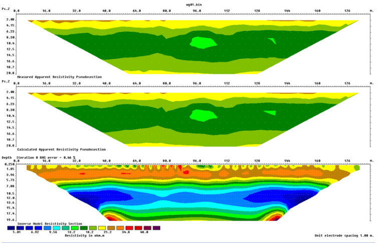
Electrical Resistivity Tomography (ERT) is a geophysical method used to map the subsurface by measuring the electrical resistivity of the ground. This technique involves injecting electrical currents into the earth using electrodes and measuring the resulting potential differences. Software such as Res2DInv plays a vital role in processing and inverting the collected data to create detailed 2D models that reveal variations in geological structures, which can indicate the presence of different rock types, soil layers, groundwater, or mineral deposits. These models are fundamental for geological interpretation and subsurface exploration.
Core Functionalities and Inversion Capabilities
Res2DInv 5.0.1 excels in performing advanced 2D inversions for both conventional and custom electrode configurations. The software supports various inversion algorithms, including smooth inversion and sharp boundary inversion, allowing users to select the method best suited to their specific geological problem. This flexibility is essential for accurately representing subsurface heterogeneities. The application is built to handle extensive datasets, processing thousands of data points efficiently, which is a key differentiator.
Broad Range of Electrode Configurations Supported
Effective geophysical data analysis relies heavily on the ability to adapt survey designs to specific site conditions and targets. Res2DInv supports a wide array of electrode configurations, crucial for Electrical Resistivity Tomography (ERT) and Induced Polarization (IP) surveys. These include, but are not limited to:
- Wenner arrays
- Dipole-dipole arrays
- Pole-dipole arrays
- Schlumberger arrays
- Combined arrays
The software’s compatibility with these diverse configurations allows geophysicists to optimize data acquisition for different subsurface scenarios, from shallow environmental studies to deeper mineral exploration, thereby enhancing the robustness of the geophysical data analysis.
Visualization and Data Export Options
Once the 2D inversion process is complete, Res2DInv provides robust tools for visualizing the resulting subsurface resistivity models. Users can interpret cross-sections clearly, identifying anomalous zones and geological boundaries. The software offers various plotting options and color scales to enhance the visual representation of resistivity and conductivity variations. Furthermore, Res2DInv facilitates the seamless export of processed data and inversion models in formats compatible with other leading geophysical software and GIS platforms, enabling further analysis and integration into comprehensive project reports.
Performance and Efficiency in 2D Inversions
A significant advantage of Res2DInv 5.0.1 is its remarkable processing speed and efficiency when handling large datasets. The software is engineered to manage surveys involving thousands of electrodes and data points without compromising performance. This capability is particularly crucial in large-scale geophysical surveys where conventional software might struggle or require extensive processing times. The rapid inversion process allows for quicker turnaround times in data analysis, making it an invaluable tool for time-sensitive projects in fields like environmental engineering and geological surveying.
Real-World Applications in Geophysics
Res2DInv 5.0.1 finds extensive application across various geophysical disciplines. Its robust 2D inversion capabilities are pivotal in:
- Site Characterization: Assessing soil and rock properties for construction and infrastructure projects.
- Mineral Exploration: Detecting subsurface mineral deposits by identifying resistivity anomalies.
- Groundwater Studies: Mapping aquifers and subsurface water flow.
- Environmental Assessments: Identifying contaminant plumes, landfill boundaries, and geological structures influencing environmental conditions.
- Geotechnical Investigations: Evaluating subsurface conditions prior to engineering work.
The versatility of this electrical resistivity software contributes significantly to informed decision-making in these critical fields.
Conclusion and Future Recommendations
Res2DInv 5.0.1 stands out as a powerful and efficient solution for 2D geophysical data inversion. Its ability to handle large datasets, support diverse electrode configurations, and deliver rapid processing makes it an indispensable tool for geophysical prospecting, geological engineering, and environmental studies. For professionals seeking advanced ERT software with superior performance, Res2DInv is a highly recommended asset for achieving accurate subsurface imaging and analysis. Further exploration of specific case studies and technical documentation can provide deeper insights into leveraging its full potential.
Frequently Asked Questions
What is Res2DInv used for?
Res2DInv is a 2D inversion software used primarily for interpreting electrical resistivity and induced polarization data in geophysical surveys. It’s ideal for subsurface investigations in various fields, including environmental engineering and geology, by creating detailed 2D models of the subsurface resistivity.
Can Res2DInv handle underwater surveys?
Yes, Res2DInv supports various electrode configurations for underwater surveys, making it versatile for geophysical applications in aquatic environments. This capability allows for comprehensive subsurface imaging regardless of the survey conditions.
How does Res2DInv compare in performance with other 2D inversion software?
Res2DInv is noted for its efficient processing speed, often outperforming other commercial 2D inversion tools, particularly with large datasets involving thousands of electrodes and data points. Its performance is a key differentiator for handling extensive survey data effectively.


Reviews
There are no reviews yet.