Download RocPro3D Pro 5.7.3 – Advanced Rock Fall Simulation Software
RocPro3D Pro 5.7.3 is an advanced software solution developed by Rocscience Inc. for geotechnical and civil engineering professionals. It specializes in simulating rock fall scenarios, offering robust tools for hazard assessment and the design of protective measures. This geotechnical engineering software is crucial for environments where rock mass instability poses a risk, enabling engineers to analyze complex geological conditions and mitigate potential dangers.
Introduction to RocPro3D
Overview of RocPro3D and Its Applications
RocPro3D is a specialized application engineered to address the challenges of rock fall analysis and mitigation in civil and geotechnical engineering projects. Its primary purpose is to model potential rockfall events, quantify their associated risks, and facilitate the design of effective protection systems. Professionals in fields such as mining, infrastructure development, and geological surveying utilize RocPro3D to ensure safety and structural integrity in mountainous or otherwise unstable geological terrains.
Core Features and Capabilities
Probabilistic Modeling and Grid Computing
At the heart of RocPro3D’s capability is its advanced probabilistic modeling approach. This method accounts for inherent uncertainties in geological conditions, such as variations in block geometry, geomechanical characteristics, and surface properties. The software leverages effective grid computing algorithms to rapidly process these probabilistic simulations, allowing for the efficient exploration of a wide range of potential rock fall scenarios and their outcomes.
Terrain Creation and Digital Terrain Modelling
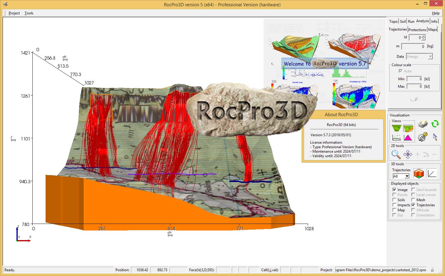
RocPro3D offers comprehensive features for creating and managing digital terrain models (DTMs). Users can import existing topographic data from various formats, including TXT, CSV, DXF, DEM, PLY, 3DS, and STL, to accurately represent the site conditions. The software then facilitates the generation of detailed mesh models, providing a precise foundation for rock fall simulations and analysis.
Integrating Soil Parameters
A key advantage of RocPro3D is its streamlined integration of soil parameters. The software allows users to define and customize soil properties, which are critical factors influencing rock behavior and fall dynamics. This capability ensures that simulations reflect realistic ground conditions, enhancing the accuracy of risk assessments. Users can efficiently input and manage these geomechanical characteristics within the system.
Analysis and Visualization Features
RocPro3D provides sophisticated tools for analyzing simulation results and visualizing potential rock fall trajectories. The software features interactive windows that allow for dynamic exploration of different parameters and outcomes. Advanced visualization options enable users to clearly understand the nature and extent of potential rock fall hazards, aiding in the interpretation of complex data and the communication of findings to stakeholders.
Dimensioning Protection Works
Beyond simulation, RocPro3D is instrumental in the dimensioning and assessment of rockfall protection works. Users can model various types of protective structures, such as barriers, nets, or berms, and evaluate their effectiveness against simulated rock fall events. This feature supports the design process, ensuring that proposed mitigation measures are adequately sized and positioned to provide the necessary safety margins.
Real-World Applications and Use Cases
RocPro3D is applied in critical real-world scenarios across geotechnical and civil engineering. For instance, it has been used in highway corridor risk assessments in mountainous regions, where detailed rockfall hazard mapping and the design of protective barriers are essential for public safety. It also plays a role in mining operations for analyzing slope stability and planning mitigation strategies, as well as in infrastructure projects requiring detailed site characterization and risk management.
Conclusion
RocPro3D Pro 5.7.3 stands as a powerful tool for geotechnical engineers and geologists involved in rockfall hazard assessment and mitigation. Its unique combination of probabilistic modeling, efficient grid computing, extensive terrain modeling capabilities, and robust design features for protection works makes it an indispensable asset for ensuring safety and reliability in challenging geological environments.
Frequently Asked Questions
What industries can benefit from using RocPro3D Pro?
RocPro3D is primarily designed for the geotechnical and civil engineering industries, particularly for projects that involve rockfall hazards. It aids engineers in assessing risks and designing protective measures for infrastructure, mining, and transportation corridors in geologically sensitive areas.
How does RocPro3D simulate rock fall scenarios?
RocPro3D uses a probabilistic modeling approach that considers variations in block shape, soil characteristics, and terrain features. It can model multiple scenarios quickly thanks to its advanced computing algorithms, providing a comprehensive understanding of potential rock fall risks.
Can RocPro3D import existing terrain data?
Yes, RocPro3D can import terrain data from various file formats, including TXT, CSV, DXF, DEM, PLY, 3DS, and STL, simplifying the terrain setup process for users and allowing them to work with pre-existing survey data.


Reviews
There are no reviews yet.