
Download SatGen Simulation Software 4 – Advanced GNSS Simulation Tool
SatGen Simulation Software 4 is a specialized application designed for the precise simulation of Global Navigation Satellite System (GNSS) data. Developed to aid engineers and technicians, this software allows for the creation of RF I/Q or IF data files, enabling offline testing of GNSS equipment. Its primary function is to replicate various satellite navigation conditions, providing a robust alternative to physical field testing for industries reliant on accurate positioning technologies.
Introduction to SatGen Simulation Software 4
Overview of GNSS Simulation
GNSS simulation plays a critical role in the development and validation of navigation systems. It allows for the artificial generation of satellite signals in a controlled environment, which is essential for testing the performance and reliability of GNSS receivers and related applications. This process is indispensable for ensuring that devices can accurately track positions and navigate under diverse and challenging conditions that might be difficult or impossible to replicate in real-world field testing.
The ability to simulate various GNSS scenarios mitigates the limitations of traditional field testing, which can be costly, time-consuming, and sometimes hazardous. By generating custom data files, engineers can systematically evaluate device responses to specific signal strengths, multipath interference, and the absence of satellite visibility, thereby enhancing the overall robustness of navigation solutions.
Key Features and Capabilities of SatGen 4
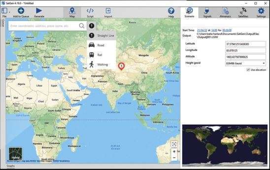
- User-generated trajectory file creation enabling precise path definition
- Extensive support for multiple satellite constellations, including GPS, GLONASS, and Galileo, across various frequencies
- Enhanced routing options and detailed map integrations for realistic scenario mapping
- Real-time tracking and sophisticated scenario management tools for dynamic testing
- Generation of RF I/Q or IF data files for offline analysis and hardware-in-the-loop testing
- Compatibility with LabSat GNSS simulators for integrated testing workflows
Applications in Engineering and Testing
SatGen Simulation Software 4 is instrumental in various engineering and testing protocols within the GNSS field. It facilitates the rigorous validation of positioning devices, ensuring their performance meets stringent requirements for applications in areas such as autonomous driving, drone navigation, and precision agriculture.
Specific use cases include detailed route testing, where engineers can simulate entire journey paths to assess continuous position tracking and signal reception quality. Furthermore, the software is invaluable for geofencing applications, allowing for precise testing of boundary detection and alert mechanisms without requiring physical presence in the target area. Its capabilities extend to simulating challenging environments, from urban canyons with poor signal reception to remote locations where field access is impractical, ensuring comprehensive device evaluation.
Comparative Analysis with Similar GNSS Software
Strengths Relative to Competitors
SatGen Simulation Software 4 distinguishes itself through a combination of advanced features tailored for modern GNSS testing needs. Its strength lies in its flexibility and the depth of control it offers users over simulation parameters.
Compared to other GNSS simulation tools, SatGen 4 offers superior capabilities in advanced routing and seamless integration with multiple mapping services, providing more lifelike simulation environments. The software’s comprehensive support for a wide range of satellite constellations and frequencies, coupled with its robust real-time scenario management, allows for more exhaustive testing protocols. This focus on detailed scenario creation and real-time monitoring provides engineers with a more adaptable and powerful platform for validating complex navigation systems.
User Interface and Usability Improvements
Recent updates to SatGen Simulation Software 4 have focused on enhancing the user experience through interface refinements and improved usability. The aim is to streamline the process of creating complex GNSS simulations and managing test scenarios.
These improvements include more intuitive navigation within the software, clearer visual feedback during real-time simulation monitoring, and streamlined workflows for importing trajectory data and configuring satellite signal parameters. Such enhancements ensure that both new and experienced users can efficiently set up and execute detailed simulation tests, contributing to faster development cycles and more reliable GNSS product testing.
Real-World Testing Scenarios Using SatGen 4
Engineers utilize SatGen Simulation Software 4 in practical scenarios to validate the performance of GNSS-dependent systems under diverse operational conditions.
- Testing autonomous vehicle navigation systems in simulated urban environments with signal obstruction due to buildings.
- Validating drone flight path accuracy and fail-safe behaviors in remote or hard-to-access geographical locations.
- Evaluating the performance of portable navigation devices for search and rescue operations in areas with intermittent satellite coverage.
- Simulating long-haul transportation routes to assess the continuous position tracking capabilities of fleet management systems.
- Testing the accuracy of geofencing alerts for logistics and security applications in simulated perimeter breaches.
Conclusion and Download Information
SatGen Simulation Software 4 provides an indispensable tool for engineers and developers involved in GNSS technology. Its advanced capabilities for creating detailed simulation scenarios, supporting multiple satellite systems, and integrating with hardware simulators significantly enhance the efficiency and accuracy of testing navigation devices. By replacing laborious field tests with controlled, repeatable simulations, SatGen 4 empowers professionals to develop more robust and reliable positioning solutions.
For those seeking to rigorously test and validate GNSS equipment, SatGen Simulation Software 4 offers a powerful and flexible solution. Its comprehensive feature set allows for the simulation of virtually any navigation scenario, ensuring that devices meet performance standards in real-world applications.
Frequently Asked Questions
What types of satellite systems can I simulate with SatGen 4?
SatGen 4 supports multi-constellation and multifrequency simulations, including signals from systems like GPS, GLONASS, BeiDou, and Galileo, allowing comprehensive testing across various scenarios. This broad compatibility ensures that users can accurately replicate conditions relevant to a wide range of global navigation systems.
How does SatGen 4 improve the testing process for GNSS devices?
By allowing users to simulate GNSS conditions in a controlled environment, SatGen 4 negates the need for extensive field tests, significantly reducing costs and logistical challenges while ensuring comprehensive scenario testing. This digital simulation approach enables the evaluation of edge cases and difficult conditions that are impractical or impossible to replicate outdoors.
Can I create custom scenarios with SatGen 4?
Yes, SatGen 4 enables users to design and test custom scenarios, including timed stops and specific trajectory paths, making it a versatile tool for various testing needs. This feature is crucial for engineers who need to validate specific functionalities or evaluate system performance under unique operational constraints.


Reviews
There are no reviews yet.