
Virtual Surveyor 2026 v10.3.1.540: Drone Surveying & Terrain Modeling Software
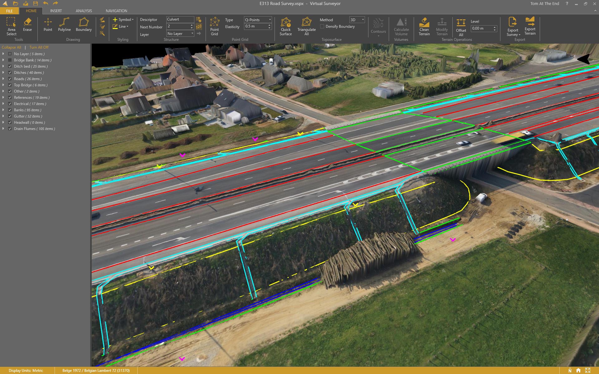
Virtual Surveyor 2026 v10.3.1.540 is a specialized software application designed to transform drone imagery and photogrammetry data into actionable survey deliverables [citation:1]. By importing orthomosaics and digital surface models (DSMs) generated by photogrammetry software (like Pix4D, DJI Terra, or Agisoft), Virtual Surveyor provides the tools to extract terrain features, create breaklines, and generate topographic maps with minimal manual fieldwork.
Version 10.3 continues the software’s evolution toward a seamless, AI‑assisted workflow, offering tools that bridge the gap between reality capture (drones) and engineering-grade deliverables (contours, cross-sections, and volume reports). The “surveyor” workflow within Virtual Surveyor functions like a CAD environment, but is specifically optimized for handling large drone datasets and producing site plans.
📐 Primary Users
This intelligent terrain modeling software is designed for professionals who rely on drone data:
-
Land Surveyors & Geospatial Professionals who want to extract accurate 3D coordinates and create surfaces directly from drone imagery.
-
Civil Engineers & Construction Managers needing to generate cut/fill maps, cross-sections, and volume calculations for site development.
-
Mining & Aggregate Professionals for stockpile volume measurement and pit monitoring.
-
Environmental Consultants & Planners mapping terrain, drainage, and vegetation features from aerial data.
-
GIS Specialists who need to integrate survey-grade terrain data into mapping workflows.
⚡ Key Features & Capabilities
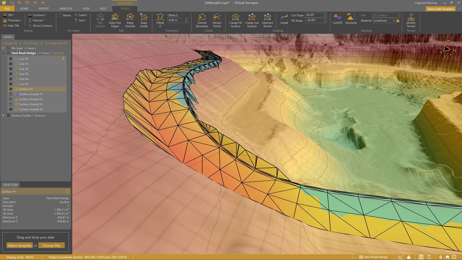
🗺️ Terrain Editing & Feature Extraction
-
Interactive TIN Editing: Refine the terrain model by adding, removing, or modifying points to ensure accurate ground representation.
-
Breakline Creation: Draw 2D and 3D breaklines to enforce sharp terrain changes (e.g., roads, ditches, ridges) in the surface model.
-
Automatic Ground Point Classification: Distinguish between ground and above-ground features (vegetation, buildings) to generate a bare-earth model.
📏 Survey & Design Tools
-
Smart Points: Place survey-grade points manually or semi-automatically on corners, edges, and features for coordinate extraction.
-
Cross-Section Generation: Generate cut and fill sections along user-defined alignments for road design or earthwork analysis.
-
Volume Calculations: Calculate earthwork volumes and stockpile quantities with configurable reference planes.
-
Surface Comparison: Compare two surfaces (e.g., as-designed vs. as-built) to generate heatmaps and calculate volumetric differences.
🗺️ Export & Integration
-
CAD & GIS Export: Output terrain data as DXF, DWG, shapefiles, and LandXML for use in software like AutoCAD, Civil 3D, and GIS platforms.
-
Stakeout Data: Export point coordinates to data collectors for machine guidance and construction stakeout.
-
Direct Integration: Designed to work seamlessly with photogrammetry data produced by Pix4D, DJI Terra, and other processing software.
🎨 User Interface & Workflow
The software typically features a dedicated ribbon interface with tools organized for the surveyor workflow, balancing the visual clarity of a map environment with the precision of CAD tools. It emphasizes a workflow that allows users to go from drone data to deliverables without leaving a single software environment.
🆕 What’s New in Version 2026 v10.3.1.540
Based on the release timeline, the Virtual Surveyor team regularly updates the software with new features and performance enhancements. Key areas of focus in recent releases have been:
-
AI-Assisted Feature Extraction: Tools that leverage machine learning to automatically identify and vectorize features like roads, parking lots, and buildings [citation:1].
-
Enhanced Orthoimage Export: Improved capabilities for generating georeferenced, high-resolution orthomosaics directly from the terrain model.
-
Performance Optimizations: Faster loading and processing of large point clouds and meshes.
🎯 Industry Applications
🌄 Topographic Surveying
-
Generate detailed topographic maps and contour plans directly from drone imagery.
-
Reduce field time by remotely mapping and extracting survey data.
🚧 Construction & Earthworks
-
Perform cut/fill analysis and generate volume reports for site preparation.
-
Create 3D terrain models for machine control and grading plans.
⛏️ Mining & Aggregates
-
Measure stockpile volumes and track inventory changes over time.
-
Monitor pit and quarry face conditions with repeat drone surveys.
🌳 Environmental & Site Planning
-
Map drainage patterns, erosion, and vegetation.
-
Generate baseline terrain models for environmental impact studies.


Reviews
There are no reviews yet.