
Download Encom ModelVision 18 – Advanced Geophysical Modeling Software
Encom ModelVision 18, developed by Encom Technology, is a specialized application designed for the complex demands of geophysical modeling and data analysis. This powerful software addresses the critical needs within the Earth Sciences, Geophysics, and Exploration fields, providing professionals with advanced tools for understanding subsurface geological structures.
Overview of Encom ModelVision 18
Introduction to Geophysical Modeling
Geophysical modeling is essential for interpreting subsurface geological information derived from indirect measurements. Tools like Encom ModelVision 18 are vital for geophysicists to construct conceptual geological models and test hypotheses against observed data. ModelVision plays a significant role in this process by offering sophisticated capabilities for inversion and visualization, enabling a deeper understanding of geological formations.
Key Features and Capabilities
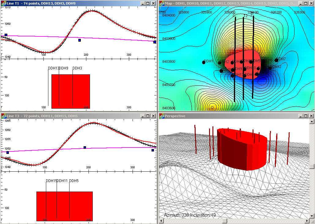
2D and 3D Modeling
Encom ModelVision 18 excels in creating comprehensive visualizations of subsurface geology. Its architecture supports detailed 2D and 3D modeling, allowing users to represent geological structures accurately. This capability is crucial for analyzing complex data sets and making informed decisions in exploration and environmental projects.
Applications in Environmental and Earth Sciences
Industries Benefiting from ModelVision
The sophisticated geophysical modeling offered by Encom ModelVision 18 serves a wide array of industries and scientific disciplines. Its robust analytical features make it an indispensable tool for professionals who require precise interpretation of subsurface data.
- Mineral exploration companies utilize ModelVision for identifying viable ore bodies by modeling potential field data.
- Oil and gas exploration sectors benefit from its 3D geological inversion capabilities to map hydrocarbon reservoirs.
- Environmental science professionals employ the software for assessing subsurface conditions, such as groundwater contamination or geological stability.
- Academic researchers in Earth Sciences use ModelVision to develop and test geophysical theories and models.
Advanced Data Visualization Techniques
Mapping and Imaging Tools
Effective data interpretation hinges on robust visualization tools. Encom ModelVision 18 provides advanced mapping and imaging utilities specifically designed to enhance the understanding of potential field geophysical data. These features transform raw data into clear, actionable insights, aiding in the identification and characterization of geological anomalies.
Integration with Extensions
Using the UBC Model-Mesh Designer
To further extend its powerful modeling functionalities, Encom ModelVision 18 supports integration with specialized extensions. One such key integration is with the UBC Model-Mesh Designer. This modular approach allows users to customize and enhance their workflows, enabling more complex and specific geophysical analysis tasks.
Case Studies and Real-World Applications
Successful Projects Using ModelVision
Encom ModelVision 18 has been instrumental in numerous successful projects across the geophysics and Earth sciences landscape. While specific project details are not detailed here, its application in mineral exploration, resource assessment, and environmental impact studies demonstrates its practical value. The software’s ability to perform detailed 3D geological inversion aids geophysicists in accurately delineating subsurface structures, leading to more efficient exploration strategies and better-informed land management decisions.
Frequently Asked Questions
What is Encom ModelVision 18 used for?
Encom ModelVision 18 is primarily used for modeling and analyzing geophysical data, particularly in fields such as mineral exploration and environmental science. It excels in visualizing subsurface geological formations using potential field data, enabling geophysicists to interpret complex subsurface structures.
How does ModelVision handle 3D geological inversion?
ModelVision 18 employs advanced algorithms that allow users to create accurate 3D models of the subsurface geology, helping to interpret complex data sets effectively through inversion techniques. This process refines geological models to best fit observed geophysical measurements.
Can ModelVision integrate with other tools?
Yes, Encom ModelVision can integrate with various extensions, including the UBC Model-Mesh Designer, which enhances its functionality for more sophisticated modeling tasks. This integration allows for expanded capabilities in geological data processing and analysis.


Reviews
There are no reviews yet.