
Download EIVA NaviPac 4.13 – Advanced Marine Survey and Navigation Software
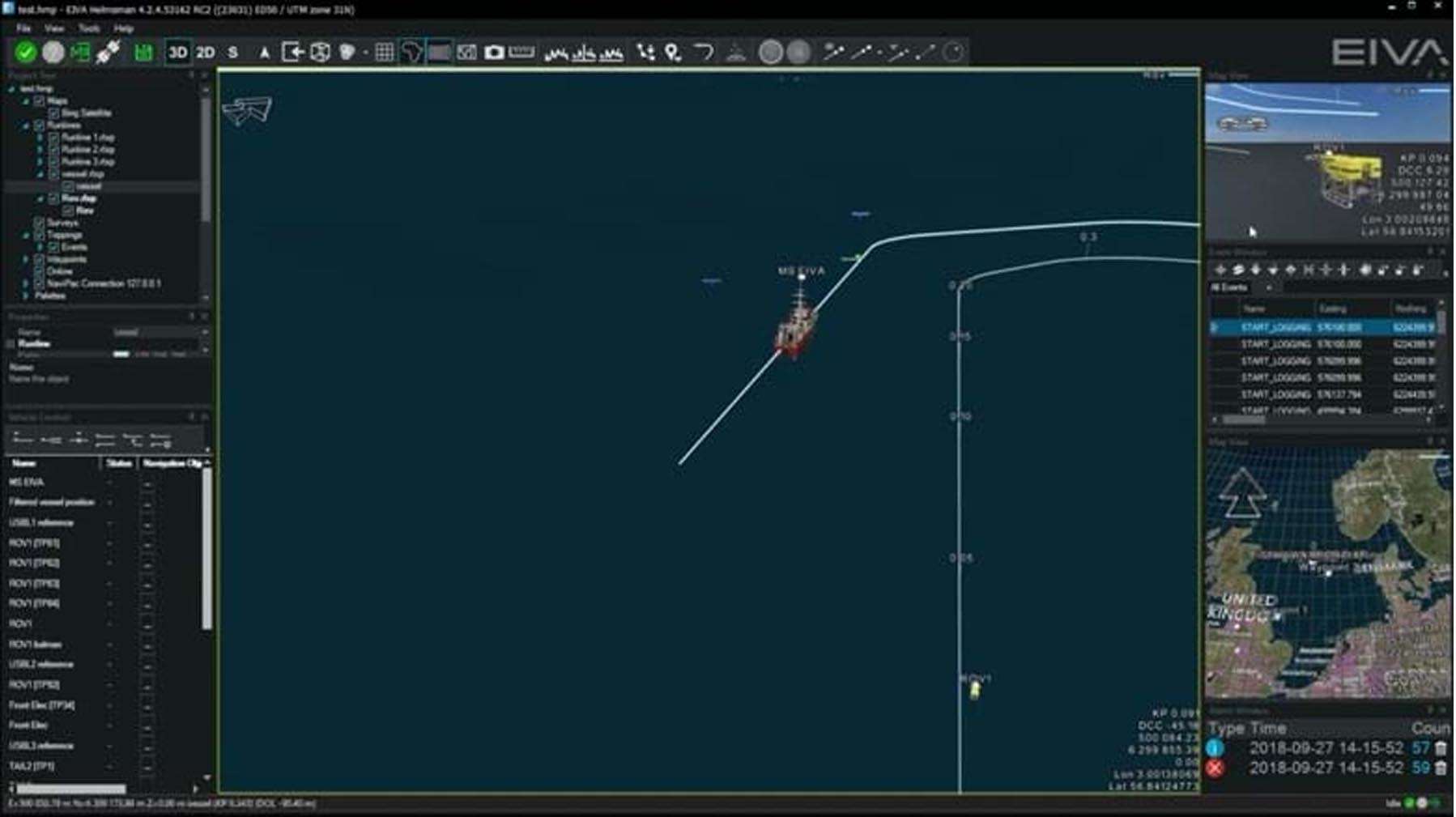
EIVA NaviPac 4.13 is a sophisticated marine survey data acquisition and navigation software developed by EIVA A/S, critically supporting operations within the offshore marine industry. This specialized application is engineered for professionals engaged in hydrographic surveying, marine geophysics, offshore construction, and the operation of underwater vehicles. It serves as an essential tool for planning, navigating, and managing complex marine survey missions, with a particular focus on ensuring data accuracy and operational efficiency in demanding offshore environments.
Comprehensive Overview of EIVA NaviPac for Offshore Marine Surveys
EIVA NaviPac has been developed by EIVA A/S to address the specialized needs of the offshore marine industry. The software plays a pivotal role in high-precision hydrographic survey applications, enabling effective data acquisition and navigation. Its adaptability to various offshore survey operations makes it a preferred choice for professionals seeking reliable performance and advanced functionalities. The software’s architecture facilitates integration with a wide array of hardware and sensor technologies common in marine engineering projects.
Integrated Sensor Data Acquisition and Real-Time Processing
NaviPac excels in synchronizing and processing data streams from multiple sophisticated marine sensors simultaneously. Its robust integration capabilities cover:
- Multibeam echosounders for detailed seabed topography.
- Side-scan sonar for imaging the seabed surface.
- Sub-bottom profilers for analyzing subsurface geological structures.
- Ultra-short baseline (USBL) and Long baseline (LBL) positioning systems for accurate underwater object tracking.
- Inertial navigation systems (INS) for precise vessel motion and orientation data.
This comprehensive sensor fusion ensures that all incoming data is time-stamped and georeferenced, providing a unified and accurate view of the subsea environment critical for detailed mapping and analysis.
Advanced Navigation and Vessel Control Features
The software provides essential real-time vessel positioning and guidance systems to maintain precise survey lines, even in challenging sea conditions. It features an integrated autopilot interface that allows for direct control of the survey vessel’s steering. This guidance system ensures that the vessel follows predefined survey routes with high accuracy, minimizing overlap and gaps in data acquisition and thereby enhancing the overall quality and efficiency of offshore survey operations.
Seabed Mapping, Modeling, and Georeferenced Data Visualization
EIVA NaviPac processes incoming bathymetric data in real-time, enabling immediate visualization of the seabed. A key capability is the generation of Digital Terrain Models (DTMs), which create detailed representations of the underwater topography. The software offers advanced visualization tools that allow users to explore and analyze both the seabed surface and sub-seabed structures, facilitating informed decision-making during marine engineering and surveying projects.
ROV and AUV Mission Planning and Monitoring Integration
The platform includes specialized modules designed for the planning, control, and post-mission analysis of Remotely Operated Vehicle (ROV) and Autonomous Underwater Vehicle (AUV) operations. NaviPac synchronizes data from the vehicle’s onboard sensors with the surface navigation data. This ensures coherent data sets and allows for precise mission execution and detailed review of underwater activities, crucial for complex tasks like underwater inspection or scientific exploration.
Specialized Tools for Pipeline and Cable Route Surveying
EIVA NaviPac offers dedicated features engineered for the meticulous planning and execution of surveys focused on subsea pipelines and communication or power cables. The software incorporates inspection tools that aid in identifying critical features such as pipeline free-spans and assessing the depth of burial. These functionalities are vital for ensuring the integrity and safety of subsea infrastructure.
Reporting, Data Export, and Workflow Optimization in Version 4.11.0
Version 4.13 of EIVA NaviPac introduces several enhancements aimed at optimizing user workflows and improving data management. Key updates include expanded support for the latest sensor models, refined data processing algorithms for tasks like tide correction and outlier filtering, and a modernized tab-based user interface that streamlines operations. The software supports the generation of standard survey reports and offers versatile data export options in formats such as XYZ, GSF, SEG-Y, and DXF, facilitating integration with other GIS and CAD software. These improvements contribute to overall performance and stability, making the survey process more efficient.
Frequently Asked Questions
How does EIVA NaviPac integrate multiple marine survey sensors in real time?
EIVA NaviPac simultaneously acquires and processes data from various sensors such as multibeam echosounders, side-scan sonar, sub-bottom profilers, USBL/LBL positioning, and inertial navigation systems. This integration provides a synchronized, georeferenced view of the seabed and sub-seabed crucial for accurate offshore surveying.
What new features and improvements are included in EIVA NaviPac version 4.13?
Version 4.13 offers expanded support for the latest sensor models, improved real-time data processing algorithms including tide correction and outlier filtering, a modernized tab-based user interface for streamlined workflows, enhanced AUV mission planning tools, and overall performance and stability optimizations.
Which professionals and industries benefit most from using EIVA NaviPac?
EIVA NaviPac is designed for hydrographic surveyors, marine geophysicists, offshore construction engineers, ROV pilots, UXO survey specialists, and teams involved in pipeline and cable route inspections in marine environments. It supports complex offshore survey operations requiring precise navigation and data acquisition.


Reviews
There are no reviews yet.