
Marine Magnetics BOB Survey Software 2026 v8.5.1.668
Marine Magnetics BOB Survey Software 2026 v8.5.1.668 is the official data acquisition, visualization, and processing software for all Marine Magnetics towed magnetometer systems (SeaSPY, Explorer, Synapse, and Overhauser series).
BOB serves as the comprehensive onboard and office processing suite for marine magnetic surveys, providing full lifecycle support: survey planning (NavAssist guide grid), real-time data acquisition and visualization, live layback correction for towfish positioning, and advanced post-processing capabilities including diurnal/base station correction, heading bias correction, and automated sensor leveling.
The software is built on a robust MS SQL database backend, ensuring data integrity and portability . The core BOB software is free for all Marine Magnetics users, with the optional BOB Analytic Module (BAM) available under commercial license for advanced magnetic mapping, target selection, and data interpolation features.
Version 8.5.1.668 (released February 26, 2026) introduces direct RS232 connection to Synapse transceivers, support for Gen 3 transceivers, enhanced layback handling, and improved import performance.
???? Primary Users
This professional marine magnetometer software is designed for:
-
Marine Geophysicists & Hydrographic Surveyors planning and executing magnetic surveys for underwater archaeology, UXO detection, and pipeline/cable routing
-
Offshore Construction & Cable Route Engineers performing pre-lay route surveys and post-lay magnetic inspections
-
Marine Mineral Exploration Specialists identifying magnetic anomalies associated with mineral deposits
-
Academic & Research Institutions conducting marine geological and archaeological research
-
Environmental & UXO Clearance Contractors detecting ferrous objects on the seabed
⚡ Key Features & Capabilities
???? Survey Planning
-
NavAssist Guide Grid – Create, save, and import survey grids with customizable line spacing, azimuth, and boundaries
-
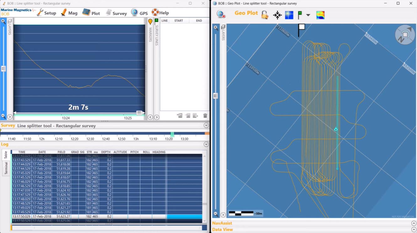
Real-Time Navigation Aid – BOB provides intuitive steering assistance to boat operators, displaying offset from the current guideline, speed, course, and towfish depth/altitude
-
AUV Survey Support – Native support for AUV-based surveys with Explorer magnetometers
???? Data Acquisition & Real-Time Monitoring
-
Setup Assistant – Guided connection configuration for magnetometer(s) and GNSS via COM/USB ports
-
High-Frequency GNSS Support – Up to 10 Hz GNSS for precise georeferencing of magnetic readings
-
Live Magnetic Profile Display – Real-time plotting with adjustable scaling, dual-pane viewing (real-time + historical)
-
GeoPlot Map View – Real-time display of vessel and towfish tracks on UTM or Lat/Long grids, with satellite imagery or GeoTIFF base maps
-
Live Layback Correction – BOB automatically calculates and applies towfish layback in real-time, maintaining accurate positioning even through turns
????️ Markers & Line Management
-
User Markers – Place color-coded markers on either the MagPlot or GeoPlot during or after the survey to note anomalies, vessel traffic, equipment changes, or other events
-
Survey Line Definition – Define survey lines directly on the GeoPlot or by selecting time ranges on the MagPlot; lines can be edited and fine-tuned at any time
-
Line-Based Processing – Display and process data on a per-line basis for targeted analysis and correction
???? Data Corrections & Processing
-
Diurnal (Base Station) Correction – Import IAGA2002 format files from INTERMAGNET observatories or Sentinel base stations to remove daily geomagnetic variations
-
Heading Bias Correction – Eliminate directional magnetic anomalies caused by the vessel’s influence
-
Automatic Sensor Leveling – Correct for sensor-specific offsets on a per-line basis
-
Layback Fine-Tuning – Adjust layback parameters during post-processing for optimal data alignment between adjacent lines
???? Data Export & Management
-
MS SQL Database Backend – All survey data, settings, markers, lines, and notes are stored in a robust, secure internal database
-
BOB Backup (.MMS) – Create portable, single-file backups of complete survey projects, including raw data, settings, corrections, and maps
-
CSV Export – Export selected data channels with user-defined corrections for third-party processing (GIS, geological software)
-
Export Data Columns – Up to 40+ available data columns including raw and corrected fields (A/B), gradients, GPS/layback coordinates, heading, depth, altitude, pitch/roll/yaw (IMU), corrections applied, line/marker identifiers, and timestamps (magnetometer clock & PC system time)
???? BOB Analytic Module (BAM)
-
Magnetic Mapping – Generate Total Field and Analytic Signal maps from gridded survey data
-
Target Identification – Enhanced target selection and anomaly picking tools
-
Profile Analysis – Advanced data interpolation and analysis features


Reviews
There are no reviews yet.