Download PointCab Origins 4.2 R18 – Leading Software for Point Cloud Processing
PointCab Origins 4.2 R18, developed by PointCab GmbH, is a specialized surveying software designed for comprehensive analysis and processing of point cloud data. This application is critical for professionals in architecture, historical preservation, geomatics, industrial planning, and forensics who require accurate digital representations derived from 3D scanning technology. It enables users to extract valuable information from dense point clouds, facilitating detailed computational modeling and precise digital documentation.
Overview of PointCab Origins
Software Capabilities
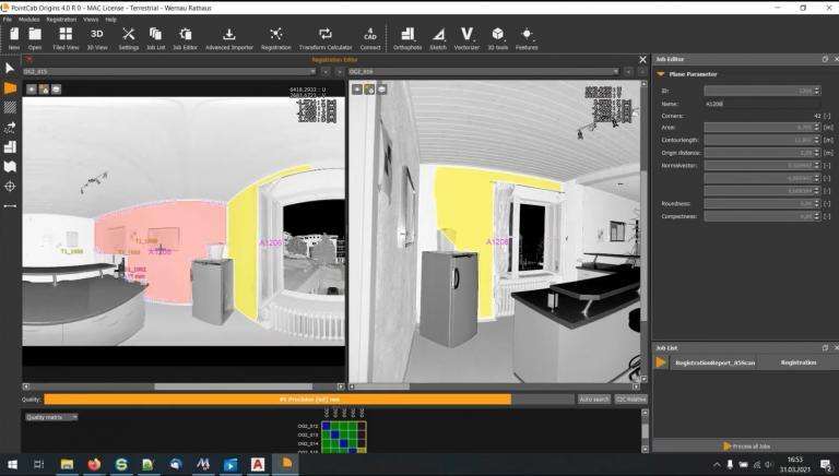
PointCab Origins is engineered to handle large volumes of point cloud data, offering robust tools for data manipulation, analysis, and visualization. Its core functionality revolves around transforming raw 3D scan data into actionable intelligence for design, planning, and documentation purposes. The software facilitates detailed computational modeling, enabling users to create precise 3D representations and conduct intricate analyses essential for complex projects.
Industry Applications for PointCab
The versatility of PointCab Origins allows for its application across a broad spectrum of industries. Its advanced point cloud processing capabilities are invaluable for creating detailed models in architecture and constructing accurate digital twins for industrial planning. For historical preservation, the software enables precise mapping and digital documentation of heritage sites, safeguarding cultural assets. Geomatics professionals utilize it for sensor-based mapping and surveying, ensuring high accuracy in land and infrastructure projects.
Integration with CAD and Other Tools
PointCab Origins is designed for seamless integration into existing professional workflows. Through its specialized interface, known as 4CAD, the software connects effectively with various CAD systems. This integration enhances the overall digital modeling process, particularly for Building Information Modeling (BIM) projects, allowing for smoother data exchange and improved collaborative efforts between design, engineering, and construction phases.
Key Features and Capabilities
- Supports both 2D and 3D data visualization and manipulation for comprehensive analysis.
- Enables accurate registration and georeferencing of ground scans, establishing precise spatial positioning.
- Provides tools for complex mapping and modeling tasks, ideal for intricate project requirements.
Use Cases: Real-World Applications
PointCab Origins has been instrumental in numerous real-world applications. In architecture, it has been used to generate detailed as-built models of existing structures for renovation projects. For historical monument preservation, the software facilitated the creation of precise digital archives of ancient sites, aiding in conservation efforts. Furthermore, its capabilities are applied in factory planning for optimizing layouts and in surveying for detailed site mapping and analysis.
Advantages Over Competing Surveying Software
PointCab Origins distinguishes itself in the surveying software market through its specialized features and integration capabilities. While many tools offer point cloud processing, PointCab excels in its direct BIM integration and its proven success in historical monument mapping, providing users with a specialized toolset for these demanding tasks. Its focus on translating raw scan data into accurate, usable models for specific industry needs offers a significant advantage in efficiency and precision.
Frequently Asked Questions
What is PointCab Origins 4.2 R18 used for?
PointCab Origins 4.2 R18 is specialized software for processing point cloud data, making it vital for industries such as architecture, surveying, and construction, where precise modeling is needed from 3D scan data. It facilitates detailed analysis and the creation of accurate digital representations of physical spaces and objects.
Can PointCab connect to existing CAD systems?
Yes, PointCab provides a user interface known as 4CAD, which allows seamless integration with CAD systems to facilitate efficient workflows and enhance building information modeling (BIM). This ensures that processed point cloud data can be easily incorporated into broader design and engineering projects.
Is PointCab suited for historical monument preservation?
Absolutely. PointCab includes features that assist in mapping and creating digital models of historical sites, allowing for preservation and analysis without physical alteration of the structures. This capability enables detailed documentation and digital archiving of cultural heritage assets.


Reviews
There are no reviews yet.