
Download QPS Qastor – Advanced Marine Navigation and Piloting Software
QPS Qastor is an advanced marine navigation software developed by QPS (Quality Positioning Services), designed to provide precise navigational data and support for various maritime operations. It is widely utilized across the marine industry, including critical sectors such as oil and gas, shipping, and transportation, to enhance safety and operational efficiency during complex voyages and piloting tasks.
Overview of QPS Qastor
Precise Navigation Capabilities
QPS Qastor offers a robust suite of tools for precise maritime navigation, catering to the demanding requirements of professional mariners. The software integrates a variety of data sources to provide a comprehensive situational awareness. Its capabilities are crucial for operations requiring accurate positioning, route planning, and adherence to navigational regulations, serving industries reliant on dependable marine transport and offshore operations.
Key Features and Functionalities
Integrative Real-Time Data Reception
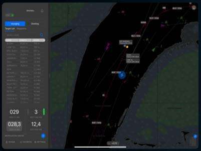
A core strength of QPS Qastor lies in its ability to integrate and display real-time data. Through the QPS Connect Server, the software can receive live meteorological information, such as wind speed and direction, and Vessel Traffic Services (VTS) data. This integration allows users to monitor current environmental conditions and traffic movements, which is essential for making informed decisions and ensuring safe passage, especially in congested waterways or complex operational areas.
High-Resolution Chart Support
The software supports a wide array of electronic chart formats, ensuring compatibility with various charting standards worldwide. This includes, but is not limited to, the S-57 standard, Primar, and other digital chart data, as well as various raster chart formats. By supporting high-resolution charts, Qastor enables users to visualize detailed navigational information, including coastline features, depths, aids to navigation, and ENC contours, thereby enhancing route planning and hazard identification.
Advanced Route Planning and Verification
QPS Qastor provides sophisticated tools for planning and verifying vessel routes. It supports trajectory modeling to predict vessel movement under various conditions and offers critical Under Keel Clearance (UKC) calculations, vital for safe transit through shallow waters. These advanced route verification functionalities help mariners ensure that their planned courses are not only efficient but also comply with safety standards, minimizing the risk of grounding or collisions.
Flexible Operation Modes and Alerts
The software is designed with operational flexibility in mind, featuring distinct modes tailored for specific tasks. This includes a dedicated docking mode that assists in precise maneuvering during port calls. QPS Qastor also incorporates customizable visual and audible alerts for potential hazards, depth changes, or proximity warnings. Furthermore, it supports wireless data output options, allowing for seamless integration with other onboard systems and mobile devices, including the transmission of NMEA data.
Applications in Various Industries
QPS Qastor is a versatile tool with significant applications across multiple maritime sectors. In the oil and gas industry, it is used for precise navigation during offshore operations, including docking and Single Point Mooring (SPM) operations. The shipping and transportation sectors rely on Qastor for efficient voyage planning and vessel traffic management. Its comprehensive features also extend to piloting services and can be adapted for advanced recreational boating needs, wherever precise navigation and real-time data are paramount.
Comparative Analysis with Similar Software
Compared to other marine navigation software, QPS Qastor distinguishes itself through its emphasis on precise real-time data integration and advanced route verification capabilities. While many systems offer standard navigation charts, Qastor’s deep support for UKC calculations, trajectory modeling, and specialized operational modes like docking and SPM makes it particularly suitable for high-risk and precision-dependent maritime activities. Its seamless integration with the QPS Connect Server for live data streams further solidifies its position as a comprehensive solution for complex navigational challenges.
Future Developments and Version Updates
QPS continually works on refining its software to meet evolving maritime industry standards and technological advancements. While specific future features are not detailed here, ongoing development typically focuses on enhancing data processing speeds, expanding compatibility with new sensor technologies, and improving user interface elements for even greater operational efficiency. Users can typically expect updates to incorporate the latest chart formats and navigational regulations, ensuring Qastor remains at the forefront of marine navigation technology.
Final Thoughts
QPS Qastor stands as a critical piece of software for modern marine navigation and piloting. Its combination of precise positioning, comprehensive real-time data integration, advanced route planning, and flexible operational modes provides mariners with the tools necessary to navigate complex environments safely and efficiently. For professionals in the oil and gas, shipping, and transportation industries, Qastor represents a dependable solution for managing challenging navigational tasks and ensuring operational integrity.
Frequently Asked Questions
What is QPS Qastor used for?
QPS Qastor is used for precise maritime navigation, supporting various applications like piloting, docking, and vessel traffic management. It integrates real-time data to enhance safety and operational efficiency.
How does QPS Qastor integrate real-time data?
Qastor receives real-time meteorological and VTS data through the QPS Connect Server, allowing users to access current information about conditions such as currents and wind speed, crucial for safe navigation.
What types of charts does QPS Qastor support?
QPS Qastor supports various electronic chart formats including S-57, Primar, C-MAP, ARCS, and DENC, making it versatile for diverse navigational needs.


Reviews
There are no reviews yet.