
Download TcpMDT 9 – Advanced Topographic and Civil Engineering Software
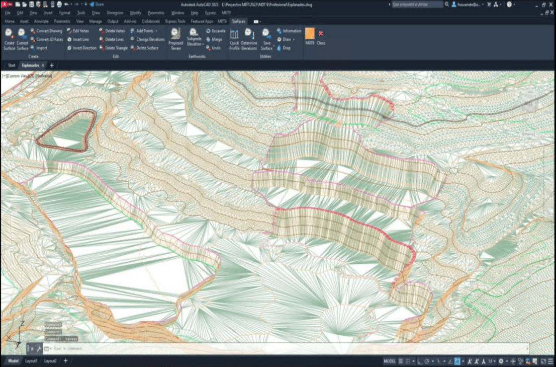
TcpMDT 9 is a specialized AutoCAD plugin developed by APLITOP, designed for the complex needs of civil engineering, geomatics, and infrastructure development. This software facilitates critical tasks in topographic surveying and civil design, making it an essential tool for professionals working in road construction, urban planning, and terrain analysis.
Overview of TcpMDT 9
Background and Development
Developed by APLITOP, TcpMDT has evolved to become a robust plugin supporting AutoCAD users in processing topographic data and executing civil engineering designs. Its development is rooted in providing specialized functionalities that are crucial for infrastructure projects, streamlining workflows from initial surveys to final design plans. The software leverages extensive experience in the civil engineering software market to offer practical solutions for modern design challenges.
Key Functionalities of TcpMDT 9
Topographic Data Processing
TcpMDT 9 provides a comprehensive suite of tools for handling all aspects of topographic data. It allows users to import, process, and analyze survey data from various sources to generate accurate digital terrain models. Key capabilities include:
- Importing raw data from total stations and GPS devices.
- Generating and editing 3D surface models from point clouds and contour lines.
- Performing volumetric calculations for earthworks and material estimation based on terrain data.
- Creating detailed topographic maps and reports.
Alignment and Profile Design
The software offers advanced features for the design of horizontal and vertical alignments, fundamental to road and infrastructure projects. Users can define road centerlines, design superelevations, and create complex profiles with ease. Specific functionalities include:
- Creating horizontal alignments using geometric elements like lines, curves, and spirals.
- Designing vertical alignments to define road grades and transitions.
- Generating and editing 3D road models based on defined alignments and cross-sections.
- Automated creation of profiles, cross-sections, and related design documentation.
Integration with BIM and Other Formats
TcpMDT 9 facilitates seamless integration into Building Information Modeling (BIM) workflows, a critical requirement for modern infrastructure development. Its compatibility extends to various file formats, enabling efficient data exchange and collaboration. The software supports OpenBIM principles, allowing for:
- Import and export of Industry Foundation Classes (IFC) files for interoperability with BIM platforms.
- Compatibility with standard CAD file formats such as DWG, DXF, and LandXML for broad data exchange.
- Integration with other APLITOP software and third-party applications to extend functionality.
Real-World Applications
Infrastructure Projects
TcpMDT 9 is instrumental in a wide array of civil engineering and infrastructure development projects. Its specialized tools enable efficient execution and management of complex tasks required in modern construction and planning.
- Road Construction: Designing new roads, highways, and access routes with precise alignment and grading.
- Urban Planning: Analyzing terrain for site development, managing utilities, and creating detailed master plans.
- Terrain Analysis: Conducting detailed site surveys, earthwork calculations, and environmental impact assessments for construction sites.
- Land Development: Preparing sites for residential, commercial, or industrial use, including grading and drainage design.
Comparison with Other Civil Engineering Tools
TcpMDT 9 distinguishes itself through its specialized focus on topographic data and alignment design within the AutoCAD environment, coupled with robust BIM integration capabilities. While other civil engineering software may offer broader functionalities, TcpMDT 9 provides a deep, practical toolset specifically tailored for engineers handling road construction and infrastructure tasks. Its emphasis on OpenBIM workflows and direct integration with platforms like BricsCAD, GStarCAD, and ZWCAD, in addition to AutoCAD, offers flexibility for various user environments.
Conclusion
TcpMDT 9, from APLITOP, offers a powerful and specialized solution for topographic surveying and civil engineering design. Its comprehensive features for data processing, alignment design, and BIM integration make it a valuable asset for professionals engaged in infrastructure development. By leveraging TcpMDT 9, engineers can achieve greater accuracy, efficiency, and collaboration in their projects.
Frequently Asked Questions
What is TcpMDT 9 used for?
TcpMDT 9 is primarily used for topographic data processing, alignment design, and integration with Building Information Modeling (BIM) in civil engineering projects. It offers a comprehensive toolkit for engineers to model terrains and manage infrastructure data effectively.
How does TcpMDT 9 integrate with BIM workflows?
TcpMDT 9 can import and export Industry Foundation Classes (IFC) format files, enhancing its compatibility with BIM platforms. This facilitates easy data sharing and collaboration among team members in infrastructure projects.
Can TcpMDT 9 be used with software apart from AutoCAD?
Yes, TcpMDT 9 is also compatible with other CAD platforms such as BricsCAD, GStarCAD, and ZWCAD, expanding its usability for users in different engineering environments.


Reviews
There are no reviews yet.