Download ExpertGPS Pro 8.92 – Advanced GPS Mapping Software
TopoGrafix ExpertGPS Pro 8.92 is a specialized geospatial mapping software developed by TopoGrafix. It is designed for professionals in geology, outdoor navigation, and GIS, enabling efficient management of GPS data and creation of detailed maps. This software streamlines workflows for users who require precise location-based data analysis and transfer.
Overview of ExpertGPS Pro
What is ExpertGPS?
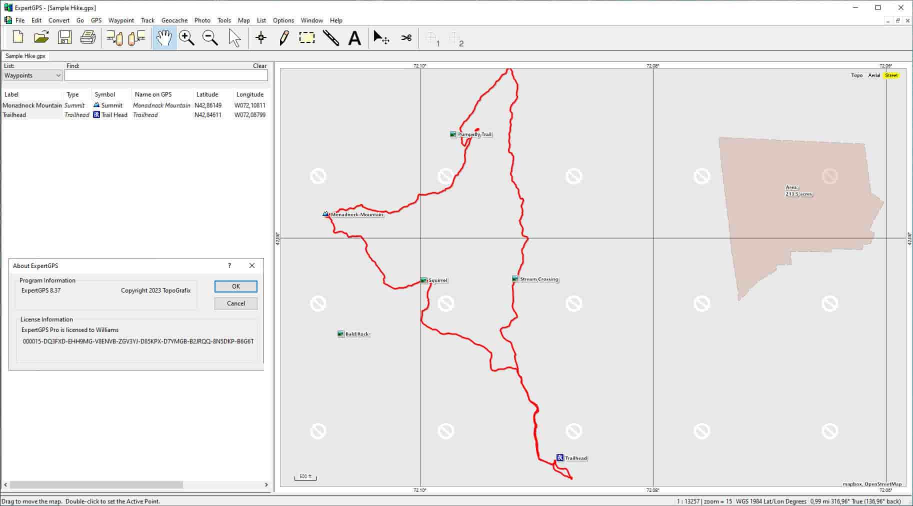
ExpertGPS Pro is a robust GPS software application that facilitates the transfer of data between your computer and popular GPS receivers. It simplifies the process of managing waypoints, routes, and tracks, making it an essential tool for field professionals. The software excels in handling various geospatial data types, offering advanced mapping functions for accurate analysis.
Compatible GPS Devices
ExpertGPS Pro ensures broad compatibility with a multitude of GPS receivers from leading manufacturers. This allows for seamless integration and data exchange, making it versatile for diverse field operations. Supported devices include those from:
- Garmin
- Magellan
- Lawrence
This extensive compatibility ensures that users can leverage their existing hardware with ExpertGPS Pro for efficient data management and transfer.
Geospatial Mapping Capabilities
Geologists and geospatial professionals can utilize ExpertGPS Pro to create and manage detailed maps with precise geological information. The software supports geo-tagging of images, allowing users to associate photographic evidence directly with specific geographic coordinates. This capability is critical for field surveys, data documentation, and creating comprehensive project maps.
Key mapping features include:
- Accurate geo-tagging of field photos
- Creation of detailed topographic maps
- Integration with GIS systems for advanced spatial analysis
Supported File Formats
ExpertGPS Pro offers extensive support for a wide array of geospatial file formats, ensuring interoperability and flexibility in data management. This broad compatibility allows for smooth data exchange between ExpertGPS and other GIS software or GPS devices.
The software supports industry-standard formats such as:
- KML (Keyhole Markup Language)
- GPX (GPS Exchange Format)
- DXF (Drawing Exchange Format)
- SHP (Shapefile)
This comprehensive format support simplifies data transfer and integration into diverse geospatial workflows.
Accuracy and Efficiency in Data Management
ExpertGPS Pro is engineered to provide superior accuracy and efficiency in managing geospatial data. It minimizes common errors encountered in data transfer and manipulation, ensuring reliable results for professional applications. The software’s interface is designed for intuitive navigation, streamlining complex tasks and reducing the time required for data processing.
Users benefit from:
- Precise data transfer protocols
- An intuitive user interface for efficient operations
- Reduced risk of errors compared to conventional methods
Practical Applications and Use Cases
ExpertGPS Pro finds extensive application across various professional domains requiring precise geospatial data handling. Its robust features make it an invaluable tool for field professionals undertaking complex projects.
Specific use cases include:
- Field Data Management for Geologists: Accurately recording and mapping geological formations, sample locations, and survey paths.
- Outdoor Navigation and Surveying: Planning routes, tracking expeditions, and marking points of interest for environmental and resource surveys.
- GIS Data Integration: Seamlessly importing and exporting data to and from Geographic Information Systems for advanced analysis and reporting.
- Coordinate Conversion: Easily converting coordinates between different datum and projection systems for standardized data representation.
Conclusion
ExpertGPS Pro 8.92 from TopoGrafix provides a powerful and accurate solution for GPS data management and geospatial mapping. Its wide device compatibility, extensive file format support, and focus on data accuracy make it an indispensable tool for geologists, surveyors, and GIS professionals. By streamlining data transfer and analysis, ExpertGPS Pro enhances efficiency and reliability in critical geospatial projects.
Frequently Asked Questions
What types of GPS devices are compatible with ExpertGPS Pro?
ExpertGPS Pro is compatible with a wide range of GPS devices, including popular brands like Garmin, Magellan, and Lawrence, allowing seamless data transfer and interaction. This broad support ensures users can integrate their existing hardware without complications.
How does ExpertGPS handle different file formats for GIS applications?
ExpertGPS supports multiple file formats, such as KML, GPX, and SHP, ensuring that users can easily transfer and utilize geospatial data across various GIS platforms without issues. This compatibility facilitates smooth data exchange and integration into diverse workflows.
Can ExpertGPS Pro be used for professional geological projects?
Yes, ExpertGPS Pro is designed for professionals in geology and other earth sciences, providing tools to accurately manage field data, create maps, and perform geo-tagging of images. Its capabilities support precise data collection and spatial analysis essential for geological research and fieldwork.


Reviews
There are no reviews yet.