Download klauPPK 1.21.4 – Precision GNSS PPK Processing Software for Aerial Mapping
klauPPK 1.21.4, developed by Klau Geomatics, is a specialized geospatial software designed for Post-Processed Kinematic (PPK) GNSS data processing, specifically tailored for aerial mapping and drone-based surveying. This application is crucial for professionals in photogrammetry and aerial surveying who require highly accurate georeferencing of their aerial imagery without relying solely on ground control points. By leveraging advanced GNSS correction techniques, klauPPK enhances positional precision for various mapping applications.
Advanced GNSS Post-Processing for Drone-Based Surveying
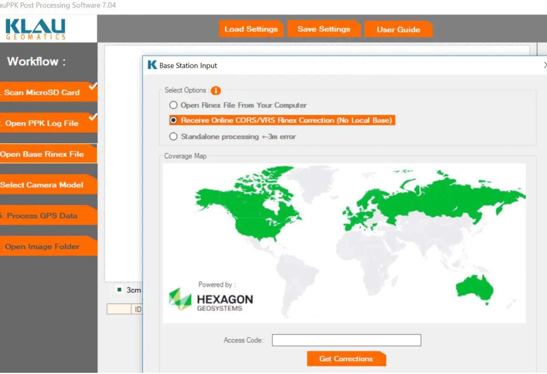
klauPPK software focuses on improving the positional accuracy of GNSS data acquired during UAV flights. It implements the Post-Processed Kinematic (PPK) technique, which refines the accuracy of the drone’s (rover) position by using data from a static base station or Continuously Operating Reference Stations (CORS) networks. This method is essential for applications in aerial surveying and photogrammetry, where centimeter-level accuracy is often a requirement for creating detailed orthomosaics, 3D models, and accurate topographic maps.
Synchronization of GNSS Data with Aerial Camera Events
Effective aerial mapping relies on precisely georeferencing each acquired image. klauPPK excels at synchronizing the GNSS observations recorded by the drone’s receiver with the exact moments the aerial camera was triggered. This meticulous timestamp alignment ensures that the calculated PPK positions accurately correspond to the camera’s exposure event. The software’s ability to handle precise event logging is fundamental for achieving accurate image geotagging, which is a critical input for photogrammetry processing software.
Integration with Leading Photogrammetry Platforms
To streamline the post-processing workflow, klauPPK offers robust compatibility with industry-standard photogrammetry suites. The software can export processed camera positions and flight trajectory data in formats widely accepted by platforms such as Pix4D, Agisoft Metashape, and Bentley ContextCapture. This seamless integration allows users to directly import the accurate georeferencing data into their preferred photogrammetry processing environment, significantly reducing manual data handling and potential errors.
Multi-Constellation GNSS Support and Trajectory Analysis Features
klauPPK software is designed to process data from multiple GNSS constellations, including GPS, GLONASS, Galileo, and BeiDou. By utilizing signals from these diverse satellite systems, it enhances data availability and improves positional solution reliability, particularly in challenging environments. The software provides advanced features for analyzing the drone’s flight trajectory, including trajectory smoothing to mitigate noise, visualization tools for inspecting the flight path, and sophisticated outlier detection algorithms to identify and address erroneous data points, ensuring a cleaner dataset for subsequent processing.
Enhancements in Version 1.21.4 for Workflow Automation and Hardware Compatibility
The recent version 1.21.4 of klauPPK introduces several key improvements aimed at increasing user efficiency and expanding hardware support. This version features enhanced integration with flight log data from a broader range of major drone flight controllers and PPK hardware. Furthermore, it includes an advanced outlier detection system and introduces a project template system designed to automate repetitive workflow configurations. These enhancements collectively contribute to a more streamlined and efficient aerial mapping data processing experience.
Real-World Applications in Aerial Surveying and Mapping Projects
klauPPK software is instrumental in a variety of real-world geospatial projects. Its high-accuracy output is essential for generating detailed orthomosaics used in land management and urban planning. The software also supports 3D reconstruction workflows for creating detailed point clouds and digital surface models of complex environments. Other applications include forestry mapping for inventory and biomass estimation, construction site monitoring for progress tracking and volume calculations, and detailed topographic mapping for engineering and infrastructure projects.
Accuracy Reporting and Quality Assurance in Geospatial Deliverables
A critical component of professional geospatial data processing is the assurance of accuracy. klauPPK provides comprehensive reports detailing the achieved positional accuracy of the processed GNSS data. These reports typically include metrics such as Root Mean Square Error (RMSE) for horizontal and vertical components, and statistics on the percentage of fixed epochs, indicating the proportion of time the PPK solution achieved centimeter-level precision. This detailed quality assurance information allows users to validate their mapping results and confidently deliver high-quality geospatial products.
Frequently Asked Questions
How does klauPPK improve the accuracy of drone-based aerial surveys?
klauPPK processes GNSS data collected during drone flights using Post-Processed Kinematic (PPK) techniques, which correct positional errors by referencing a base station or CORS data, achieving centimeter-level accuracy without ground control points. This precise synchronization with camera triggers ensures accurate georeferencing of images for photogrammetry projects.
Which photogrammetry software is compatible with klauPPK output files?
klauPPK exports processed camera positions in formats compatible with widely used photogrammetry suites like Pix4D, Agisoft Metashape, and Bentley ContextCapture, enabling a smooth integration into mapping workflows.
What are the latest features introduced in klauPPK version 1.21.4?
Version 1.21.4 introduces enhanced flight log integration from major drone flight controllers, expanded support for new PPK hardware, advanced outlier detection algorithms, a project template system for workflow automation, and improved user interface for trajectory visualization and reporting.


Reviews
There are no reviews yet.