
Leica PinPoint 2026 v4.2.1
Leica PinPoint is a professional point cloud processing and modeling software that simplifies complex tasks with intuitive tools and automation, making it easy to produce 2D and 3D floor plans, generate orthoimages, and extract exact measurements. Developed by Leica Geosystems, a global leader in reality capture technology, PinPoint adapts to workflows ranging from single scans to complex multi-scan environments, scaling seamlessly with project requirements. Version 2026 v4.2.1 continues Leica’s legacy of making point cloud processing accessible to professionals of all skill levels—from seasoned surveyors to those just beginning with laser scanning technology. Whether performing guided scan alignment, intelligent modeling, or rapid data exports, PinPoint delivers the precision, productivity, and end-to-end workflow efficiency that modern reality capture projects demand.
???? Primary Users
This professional point cloud processing software is designed for:
-
Land Surveyors & Geomatics Professionals processing and registering laser scan data for topographic surveys.
-
Architects & Building Information Modelers (BIM) creating accurate 2D and 3D floor plans from point clouds.
-
Construction & Civil Engineers performing as-built verification and progress monitoring.
-
Facility Managers & Asset Managers documenting existing conditions for renovation and maintenance.
-
Forensic & Public Safety Professionals documenting crime scenes and accident sites.
⚡ Key Features & Capabilities
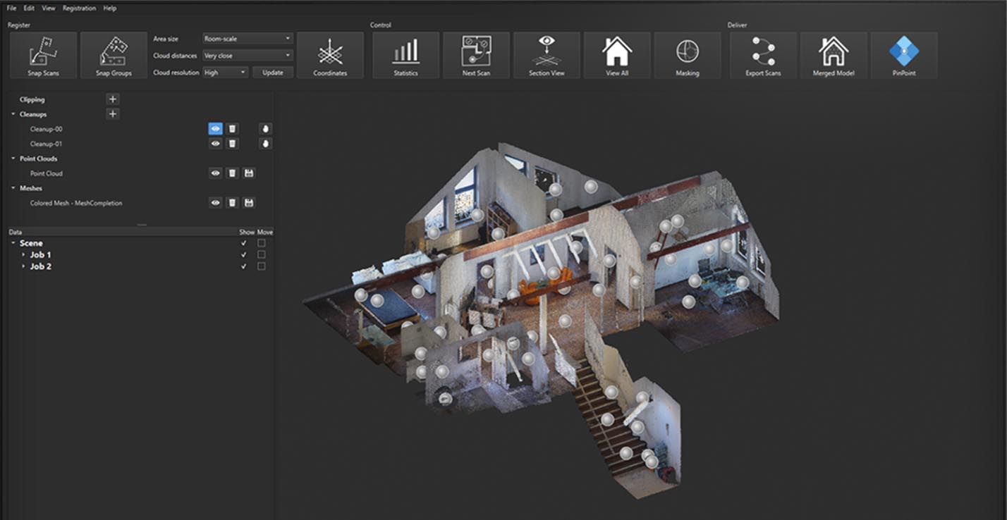
???? Scan Registration & Alignment
Guided Scan Alignment:
-
Automated and manual registration methods
-
Visual alignment tools for cloud-to-cloud registration
-
Target-based registration (checkerboard, sphere, custom targets)
-
Multi-scan environment management
-
Real-time registration quality feedback
Scalable Processing:
-
Single scan to hundreds of scans
-
Incremental registration for large projects
-
Geo-referencing with control points
-
Bundle adjustment for global consistency
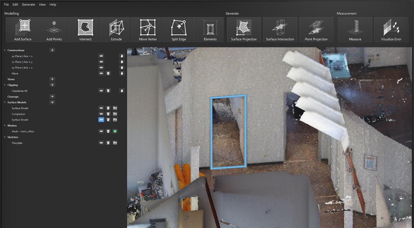
???? 2D & 3D Floor Plan Generation
Automated Wall Detection:
-
Intelligent wall and room boundary detection
-
Automatic extrusion to 2D floor plans
-
Door and window recognition
-
Opening and niche detection
3D Modeling:
-
Extrude 2D plans to 3D models
-
Surface and solid model generation
-
Edge and corner refinement tools
-
Export to CAD/BIM formats
???? Exact Measurement Extraction
Measurement Tools:
-
Distance, area, and volume measurements
-
Point-to-point, polyline, and surface measurements
-
Vertical and horizontal distances
-
Cross-section and profile extraction
Intelligent Snapping:
-
Snap to corners, edges, and surfaces
-
Centerline detection for pipes and conduits
-
Automatic dimension annotation
????️ Orthoimage Generation
Image Creation:
-
Orthoimage from point cloud (elevation, plan, cross-section)
-
Image enhancement (brightness, contrast, sharpness)
-
Tile and large-format orthoimage export
Documentation:
-
Annotation overlay (text, dimension, label)
-
PDF and image export for reporting
????️ Point Cloud Visualization & Navigation
Visualization Tools:
-
Color by elevation, intensity, classification, RGB
-
Clipping boxes and cross-section planes
-
Level of detail (LOD) for performance
-
Multi-scan side-by-side display
Navigation:
-
Walk/fly with real-time rendering
-
Zoom to region, bookmarks, saved views
???? Data Import/Export & Interoperability
Import Formats:
-
Leica proprietary (RWP, ZFS)
-
Industry-standard (LAS, LAZ, E57, PTX, PTS, XYZ, DXF, DWG, LandXML)
-
Survey control points (CSV, TXT)
Export Formats:
-
CAD (DWG, DXF)
-
GIS (Shapefile, GeoTIFF)
-
BIM (IFC)
-
Mesh (OBJ, PLY, STL)
-
Orthoimage and floor plan (PDF, image)
???? Project Management & Automation
-
Single-project repository: scans, registration, models, deliverables
-
Batch processing for routine operations (orthoimages, floor plans, point cloud export)
-
Python API for custom workflow automation
???? What’s New in Version 2026 v4.2.1
-
Fast Registration Engine (2026) – 2× faster cloud-to-cloud alignment for multi-scan projects
-
Enhanced Floor Plan Automation – AI-assisted wall/room detection; reduced manual cleaning (<10% touch time)
-
3D PDF Export – Embed interactive 3D model and orthoimages for non‑CAD stakeholders
-
BLK ARC & BLK2FLY Integration – Native support for autonomous scanning robots (SLAM-based)
-
Real-Time Colorization – Live RGB overlay from external camera during scan alignment
-
Web-Based Sharing – Direct upload to Leica Cloud with password-protected viewing
???? Industry Applications
???? Architecture & Building Documentation
Create accurate as-built floor plans, elevations, and sections for renovation, retrofit, and historic preservation.
????️ Construction & Civil Engineering
Monitor construction progress, perform as-built vs. design verification, extract cross-sections for earthworks.
???? Facility Management & Asset Management
Document existing mechanical, electrical, and plumbing (MEP) systems; maintain up-to-date building information.
????️ Infrastructure & Transport
Survey bridges, tunnels, roadways, and railways; generate orthoimages for condition assessment.
???? Forensic & Public Safety
Document accident scenes, crime scenes, and fire scenes with accurate measurements and 3D visualization.


Reviews
There are no reviews yet.